|
A66 Greta Bridge, Mortham Tower,
River Tees, Eggleston Abbey, Barnard Castle, Co Durham.
[16.3 km]
Sun 12 Apr 2015 |
|
|
|
Lat/Long: 54.512839, -1.864331
I set off about 11am to drive to Greta
Bridge just off the A66. Heading north along the M6 there was a hold up
north of junction 36 due to two cars being in a crash. It was very windy
during the morning and when I reached the A66 east of Brough a lorry was
on its side on the westbound carriageway and debris on the east bound,
the way I was going. I didn’t have any problems. I parked in a short
stretch of the old road that is now a dead end. |
|
|
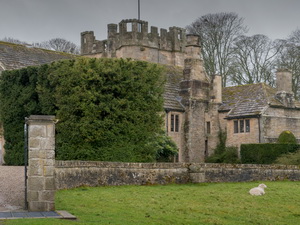
Walking back along the
road I joined a path across fields near the original Greta Bridge. The
path went under the A66 then across fields to Mortham Tower Buildings.
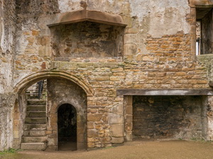
It is a private residence and a Grade I listed fortified courtyard house
and Pele Tower dating from around (1485-1509). It was all well looked
after but I couldn’t see anyone around. The access road took me down to
an interesting bridge over the River Greta and I followed the road past
Rokeby Park then joined a path by the bank of the River Tees. |
|
|
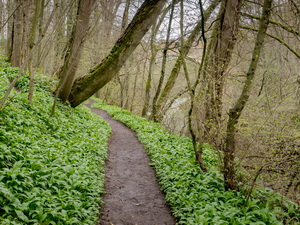
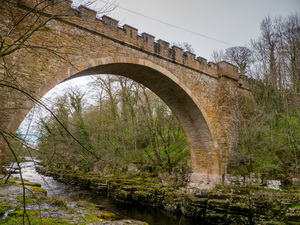
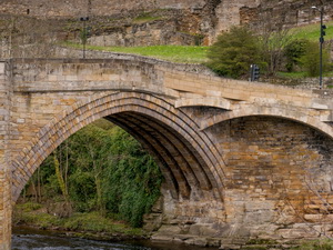
It was a pleasant walk
all the way to the very impressive Abbey Bridge. It’s a grade II Road
bridge built in 1773 for John Sawrey Morritt. It looked very impressive
from the river bank but I then had to climb steeply up a muddy bank to
reach the road. |
|
|
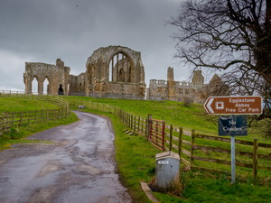
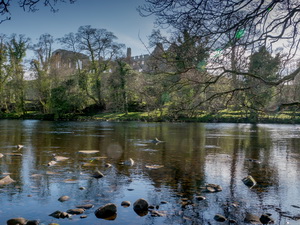
The I took the minor road
to Eggleston Abbey whose ruins looked very impressive on the skyline.
There is a small car park next to the ruins and although there are
opening times shown I don’s see how the times could be enforced as it
isn’t manned. I wandered through the impressive ruins and enjoyed the
views across the Tees. |
|
|
The Abbey was founded in
the late 12th century at some point between 1168 and 1198. The founders
were the Premonstratensians who wore a white habit and became known as
the White Canons. Remains include much of the 13th century church and a
range of living quarters, with traces of their ingenious toilet drainage
system. It was such a nice spot I sat down to enjoy my late lunch of
sandwiches. |
|
|
|
|
|
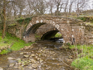
I had the whole place to
myself. Steeply down a bank to the north I descended to Bow Bridge a
grade II Packhorse bridge from around the 17th century. It is hog-backed
with a single segmental arch and low flat-topped parapets. Next to it is
the current road bridge. Up the road I followed a path across fields and
into a caravan park. |
|
|
|
|
|
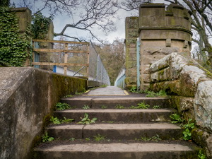
Although I was on a
public footpath there were no markers and I only found the way out when
I saw some walkers approaching the other way. The path took me to the
B6277 which I followed to the bridge crossing to Barnard Castle. I
didn’t cross the Tees at this point but continued to the Aqueduct Bridge
which also carries the footpath. To the right was a riverside footpath
that took me to an interested area of seats and decorative flags. |
|
|
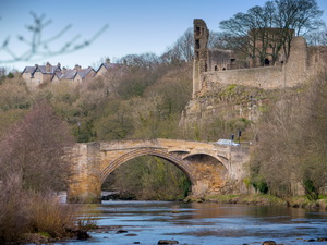
It was the site of the
Barnard Castle Gas Works but nothing remains today. It was fascinating
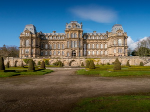
looking up at the magnificent castle. I walked up the street to the
‘Butter Market’ building then right to have a look at the front entrance
to the
Bowes Museum. I will have to return sometime to visit it properly. |
|
|
I left the town by a path
that took me past sports fields down to the bank of the Tees. Further
along I was able to see the Eggleston Abbey Ruins high up across the
river. I reached Abbey Bridge again and crossed it to follow the road
all the way to the A66. It was quite busy and with no footpath it wasn’t
very enjoyable. Crossing the A66 I came to a short path that took me to
the old road then down to the Greta Bridge and back to my car. |
|
|
|
Eggleston Abbey across the Tees |
|
|
|