|
Arkengarthdale, Hoove,
Faggergill Moor, North Yorkshire. |
|||||||
|
OS Grid Ref: NY 97734
04810 On the Tan Hill – Reeth road I found a large lay-bye to park the car. When I arrived about 8am there was a large coach parked there with the engine running. It soon left and headed down towards Reeth. I walked back a short distance towards Punchard Gill Bridge then turned right into the field to follow the path down to the footbridge over Arkle Beck. On the far bank there was a sign which seemed to advise walking round the outside of the field. I didn’t see the point as the official path took me to a barn and then the road. On the minor road I had a steep hill to walk up to Seal Houses then left up a track towards High Faggergill. After Sealhouses the track was unsurfaced but in good condition. |
|
||||||
|
I reached the High
Faggergill farm house to see that it was occupied but nobody about. The
track continued but I left it to head up the fell to the right. I was
heading for Hoove and the trig post and wasn’t sure how it would be
underfoot as there was no footpath. Following sheep tracks it was fairly
easy going. |
|
||||||
|
Over the Hoove plateau there were some boggy sections but nothing too bad. The trig post was on its own with no footpath access. |
|
||||||
|
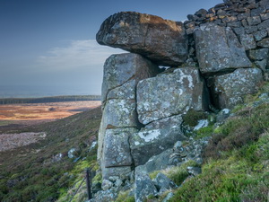
Continuing north I descended to a very rough area of tussocky bog but not as bad as it looked. There was a line of shooting butts but no vehicular access to them. I headed for a wall in the distance which is where the Fryingpan Stone is shown on the map. There was a rocky outcrop at the end of the wall but nothing I would describe as a fryingpan. There was a small sheltered alcove that looked like an old small quarry for building the walls. |
|
||||||
|
I used it to shelter from the cold wind and eat my sandwiches. To the north I could see Bowes Castle in distance. I then headed west to start my descent towards Faggergill Mines. Descending a gully it was easy walking and there were more shooting butts. After a steep descent of Faggergill Scar I joined a track which took me down to the old mine area. I could see a substantial building ahead so followed the track towards it. On the way was a mine entrance which didn’t seem to have anything preventing access to it. |
|
||||||
|
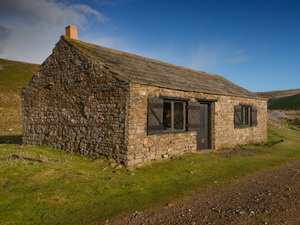
The building turned out to be a large shooting hut converted from a stone building. It was unlocked and very tidy inside with a large fireplace, table and chairs. |
|
||||||
|
|
||||||
|
After a look round I continued down the track which took me back to High Faggergill Farm. |
|
||||||
|
I headed SW to cross fields and connect with another farm track. I had to shelter behind one of the walls for a time as a heavy shower of hail blew across. The track took me down to Low Faggergill and down to the minor road I’d originally walked up. I crossed the field back to the footbridge over Arkle Beck and the short walk back up to the Reeth road and the car. |
|
||||||
|
|
|||||||