|
Pistyll Rhaeadr waterfall,
Glan-hafon, Wales. |
||||
|
OS Grid Ref:
SJ 07621 29364 It’s been many years since I’d been walking in Wales so I decided to visit it again and also check how it is for driving there during the morning rush hour. As expected the M6 motorway south was very busy, even just after 6am. Then it was the M56 & M53 and into Wales to Llanrhaeadr-ym-Mochnant. I was heading for a small car park at the base of Pistyll Rhaeadr waterfall. |
|
|||
|
There was about 5 miles of single track road from the village and my heart sank as I was a there was a ‘road ahead closed’ sign. I drove along anyway and eventually came to some road works. A man told me there was a way round so I returned to the village and followed the diversion signs along a very narrow and twisty lane. I eventually reached the very rough car park which is the roughest and rockiest I’ve ever seen. The weather was bad. Low mist and the treat of rain. I set off back along the road to find a path running diagonally up the hillside. |
|
|||
|
It was a lovely green track between deep bracken. A left branch I was hoping to take another path which was lost under deep undergrowth. I had to take a longer diversion to reach the path I wanted. I returned to the waterfall path and followed it to a metal bridge with interesting dragon motif gates. The waterfall looked very impressive but dark overcast rainy weather prevented me getting a decent photo. |
|
|||
|
The path continued through dark woodland then emerged onto open hillside at a wooden stile. The narrow path headed uphill for a while though very deep bracken. I’m glad I was in full waterproofs or I’d have been soaked from the wet fronds. It cleared when I reached an area of old mine workings. I took advantage of the old mine tracks to climb the hillside. Even with the bad weather it was a pleasant climb. As I approached the pass summit I also approached the cloud level. |
|
|||
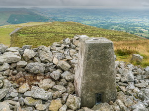
|
The path became horribly boggy where I left it and headed by a fence up the side Glan-hafon. There was no path and it was difficult at times. I was still in cloud near the summit but the ground had improved. The mountain has two summits shown on the map. The western one is 608m and the next slightly lower at 607m. The trig post is on the last and lowest summit. As I reached it the cloud began to lift and I had some nice views across the Tanat Valley. |
|
|||
|
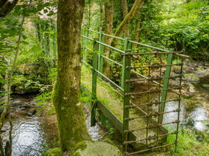
I descended to the north and joined a track around the north side of the mountain that joined a tarmac road at Ty-newydd. I left the road to descend though fields where a path is shown on the map but no sign of it or path markers on the ground. At another narrow lane I crossed over and down a steep field to the Afon Rhaeadr River. At an interesting metal footbridge I crossed over and up to the road where I walked back to the car. |
|
|||
|
|
||||