|
Whitbeck, Black Combe, Cumbria. |
||||
|
OS Grid Ref:
SD 11913 83945 Its seven years since I last visited Black Combe so I decided to climb it again but by a different route. The mountain is visible on a clear day from as far as The M6 just south of Lancaster. It can be seen to the west across Morecambe Bay as a whale like profile. From the main A595 it looks less impressive. I left my car in the lay bye in front of the church at Whitbeck and walked up the minor lane towards Midtown Farm. The track deteriorates steadily as I approached Whitbeck Mill where I left the track and joined a path along the base of the mountain. |
|
|||
|
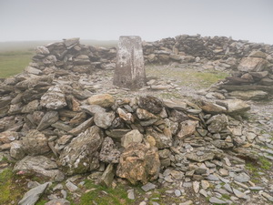
There was a lot of bracken about but the path was wide enough for it not to be a problem. Fell Cottage was an interesting building. It was still standing but didn’t look like it had been occupied for many years. There was no vehicle access to it. Over Hallfoss Beck and at Butcher’s Breast the path began to climb steeply up the west side of the fell. I passed a sheepfold where a few sheep were sheltering from the wind then continued up into the cloud. The early morning had been clear but now it looked like I wouldn’t get any views from the summit. I followed the path for a while longer then left it to cross the Charley Fold ruined sheep fold. Across more open ground I reached Hentoe Hill then turned south to find the faint path to Black Combe summit. At the summit was an O.S, trig post inside a circular stone wall. |
|
|||
|
I was in cloud with no distant views. I started my descent to the south using the main path which was substantial and well used. At Townend Knotts I descended below the cloud and had a nice view out to sea. I left the main path and took a minor one to a promontory at Seaness. It was a nice viewpoint but the continuing path shown on the map wasn’t there. I eventually found a track descending diagonally and steeply down the hillside towards Townend Hall farm. The 50K map shows a path to the farm but I couldn’t see any sign of it. The main road wasn’t far below so I climbed over a tied up gate, across a field to a wooded area then through a farm gate back to the main A595. The short walk back to the car was uncomfortable as there is no footpath on the busy road. I tried to have a look at the church but it was locked with a metal grill across the front door. |
|
|||
|
|
||||