|
Loch nan Cuaran, Anson N9857
bomber crash site, Ben More Assynt, Scotland.
[20.2 km]
Thu 03 Jul 2014 |
|
|
|
OS Grid Ref:
NC 25114 21610
Lat/Long: +58.148674, -04.973203
I’d spent the night by the A894 a couple of miles from the Inchnadamph
car park so only had a short drive to the start of the walk and was able
to get away early. The overnight rain had stopped but the weather
continued gloomy. I was heading for the crash site of an Avro Anson
bomber that crashed in 1941 on a training flight. I found it on my last
visit but this time wanted to walk there by a different route. I
followed the main track by the River Traligill but left it before the
bridge to head up Allt Poll an Droighinn by a small path. |
|
|
|
Interesting house near Inchnadamph |
|
|
The path continued into a
high valley where a small shelter had been built near where the path
splits. I took the right branch to head east towards Loch nan Cuaran.
Some sections of path had to be marked by cairns as there was no path to
see. The path improved as I got higher and eventually vanished when I
reached the Loch. |
|
|
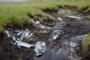
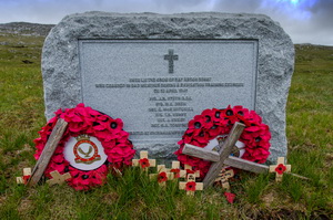
I had to make a detour
round some very boggy ground but after climbing a bit more was able to
see the large crash site memorial stone in the distance. Before reaching
the stone I stopped to look at one of the engines that stood upright on
the ground. The other engine was nearby. Bits of wreckage were strewn
around but the new memorial stone stood there clean and tidy. In front
of it is a circular area of stones placed over the graves of the six men
who died during and after the crash. |
|
|
|
|
One of
the Armstrong Siddeley engines |
|
|
|
|
One of
the Armstrong Siddeley engines |
|
|
I continued south
climbing steadily and fortunately in better weather than the last time I
was here. It wasn’t sunny but at least I could see the surrounding
hills. Just over a mile ahead I reached a loch then started the climb up
Conival. |
|
|
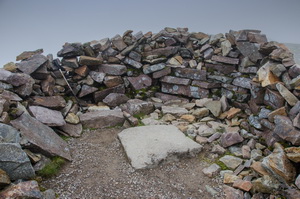
It was rough in places
but easy to follow. The only concern was the wind which was getting very
strong. After the steepest part of the climb I had trouble standing in
the wind. By the time I reached the summit stone shelter it was easier
to stand. There wasn’t a traditional trig post but a metal bolt set in a
square concrete block within the shelter walls. To the east along a mile
of rocky ridges was Ben More Assynt. It wasn’t much higher that Conival
but I decided to have a look anyway. |
|
|
The ridge undulated quite
a bit and wasn’t nice to negotiate in the wind. At times it was very
difficult to stand. Just before the summit on the final approach a
strong gust of wind blew me over. I fell forward and rolled over. My
shins banged on the rocks and my left leg received a deep cut. My main
concern was banging my head which also was cut. I lay there to collect
my thoughts and checked things were OK and no serious damage done. My
only option was to get down as quickly as possible. I reversed my walk
back to Conival and fortunately the weather began to improve. |
|
|
Two other walkers had
just arrived at the summit when I did. I didn’t stop but set off down to
the waterfall at Allt a Choinne Mhill. At first the descent to the River
Traligill is quite steep but eventually levels at the river valley. It
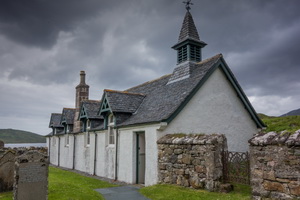
is a delightful riverside path to walk. I continued on to the track then
back to the car. I had a quick look in the local church where some
historical photos were on display. My original plan was to stay another
night in Scotland but instead decided to drive straight home and visit
the local hospital in the morning to get my head cut checked. It was a
long drive of 430 miles but the roads were clear and I reached home
about 23:30. |
|
|
|
The
Church at Inchnadamph |
|
|
|