|
Allendale, Crawberry Hill, Stobs
Cross, Spitalshield Moor, Northumberland. |
||||
|
OS Grid Ref:
NY 8375 5583 The weather forecast was due to go downhill from Wednesday so I’m heading for the hills on a Tuesday. I had a pleasant drove over Hartside Pass to Allendale and left my car on the town square. I started my last walk here on Wed 04 June. I headed east along Shireburn Road and past Struthers where the road ends. I was then on the same moorland track as last time. Approaching Long Rigg I took a left fork into new territory. |
|
|||
|
The weather continued gloomy and very overcast. At Foumart Hills I came to a substantial wooden shooting hut. It was securely locked. |
|
|||
|
The track was easy walking and I continued into worsening weather. After crossing the wonderfully named Wapweasel Burn the stoned track vanished and I had to find my way though rough ground towards a distant gate. At the gate the rain started and as I stopped to put my waterproofs on a rather haughty woman came up the far track on a horse. She didn’t say much as she turned her horse round and plodded back the way she’d come. |
|
|||
|
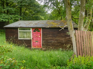
The track continued between walls to High Eshels where I was back on tarmac. I continued for a while then left to Ham Burn and a ford, which was dry. On the corner of another left turn was a ram shackled wooden cabin with old curtains up that looked if it had been lived in once, but not now. |
|
|||
|
I followed the road to the end near Spital Shield the through a gate into the fields. It was fairly straightforward following field boundaries and gates to reach Spitalshield Moor where I headed out across open and featureless land. |
|
|||
|
I was looking for Stobs Cross which is marked on the map as ‘remains of’. I was almost on top of it when I found it. There is nothing to show its location. It is a the cross base with a rectangular mortise hole and is down at ground level. A few other stones were lying by the side but I don’t know if any could have been part of the cross shaft. |
|
|||
|
Continuing across open land I reached a gate at Coldcoates Syke then joined a track to join with the main track across the moor. A path branch was signposted but there was no sign of a path. |
|
|||
|
I continued straight on to the next wooden Shooting Hut and North Church Lands. Then it was south over open ground to Gaterley Hill and the trig post. |
|
|||
|
Over the top I reached a track and followed it to tarmac at Leadside Bank. |
|
|||
|
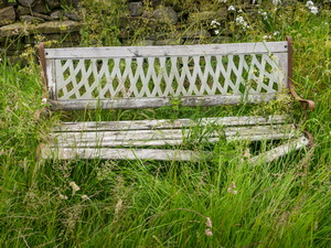
There was an interesting stone bench by the road. |
|
|||
|
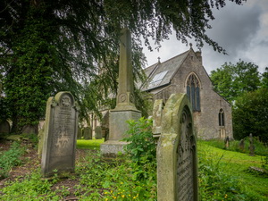
Downhill I reached the main road back into Allendale but instead of going back to the car went to St Cuthbert’s Church first. To the right and by a large tree was the grave and monument to Isaac Holden who’s water trough I’d seen on my last visit. "In memory of Isaac Holden, a native of this parish who died November 12 1857 aged 51 years. He gained the esteem and respect of the public by his untiring diligence in originating works of charity and public usefulness. Upwards of 600 persons subscribed to erect this monument". |
|
|||
|
 Isaac Holden |
|||
|
Isaac Holden (c.1805 - 1857) was a local tea seller and fund raiser. There is an Issac Holden article from the Hexham Courant here.
|
||||
|
|
||||