|
Acton Moor, Dryburn Moor,
Chimneys and Smelting Flues, Allendale, Northumberland
[12.9 km]
Wed 28 May 2014 |
|
|
|
OS Grid Ref:
NY 8113 5318
Lat/Long: +54.873035, -02.295536
The bad weather forecast was mostly right. I drove north along the M6 to
Penrith in gloomy weather then over Hartside Pass in mist and rain. By
the time I’d gone through Nenthead and on to minor road over Dryburn
Moor the mist was very thick with constant drizzle. The road was narrow
and fenced but I was able to find a wide area of verge where vehicles
had parked before. |
|
|
|
Shooting
huts in the mist |
|
|
I set off east in full
waterproofs to a bend in the road. I took a gate to the right which took
me into the abandoned Flakeburn Quarries. The access track had been
recently stone surfaced but I couldn’t see any obvious uses for the
quarry area. I climbed out and up on to the featureless moor. I headed
for a long wall to the east and followed along its west side. The ground
was terribly wet with areas of thick reeds. I crossed the wall at a gate
to find better ground but it didn’t last long. Eventually and thankfully
I reached the track to the north of Hagg Plantation. |
|
|
I followed it west though
thick mist and rain until the two shooting huts appeared though the
mist. They were substantial and in good condition but unfortunately
securely locked. The track continued for a while up to some shooting
butts. They were sunken timber framed butts in very good condition. My
route was over the featureless Acton Moor so I left the easy track and
was back on rough moor. With no wall or fence to follow navigation was
difficult so I just kept heading upwards till I reached what I
considered the summit. I continued over the top and descended back to
the road. |
|
|
I followed to the right
and took a signposted path off to the left which is called Carrier’s Way
on my map. I continued to my next objective of a stone chimney that I’d
seen from a distance last week. With thick mist I couldn’t get a decent
photo but the double flue entrance was interesting. It is the highest of
two chimneys and was fed by a stone tunnel flue that ran from a Lead
Smelting Mill near Allendale Town. The flue was partly collapsed and had
a rough track next to it. |
|
|
|
|
|
At Fell House I joined a
surfaced road to Frolar Meadows Farm. On the left was an access door way
into the flue. At the next road there was another access as the flue
passed under the road. The continuing flue didn’t have a public path
shown on the map but I still followed it through the fields. |
|
|
|
Two
flues diverge onto the moor |
|
|
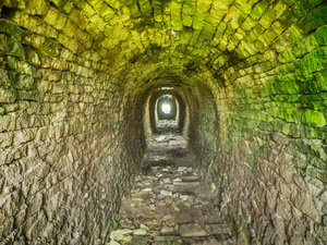
Most of it was in good
condition and I was able to get into one collapse to photograph its
interior. I reached a bridleway where another flue headed back up onto
the moor. It would have been difficult to follow through the fields so I
continued on the track to walk back along the road to Fell House then
through some old working to join the second flue across the moor. |
|
|
|
The
lower but taller chimney |
|
|
There was a path along
most of its length and I soon reached the second chimney which was
smaller in diameter than the first but much taller. I continued up to
the higher chimney which is the first one I visited. The weather
continued wet and misty as I retraced my steps back to the road and my
car. |
|
|
|