|
Allendale, Hartley Moor, Kevelin
Moor, Carrshield, Northumberland
[16.4 km]
Wed 21 May 2014 |
|
|
|
OS Grid Ref:
NY 8019 4525
Lat/Long: +54.801723, -02.309629
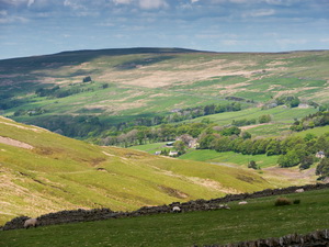
After a great drive I passed through Nenthead and reached the head of
Allendale where I left my car in a small parking area near the
wonderfully named property of Portobello. I headed NE along the road
towards Shivery Hill in morning sunshine. It felt cold as I set off and
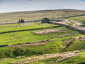
didn’t feel any warmer as I walked up the lane. I passed a building on
my left called Mutton Hall but it seemed nothing more than an old barn
and didn’t qualify for such a grand name. |
|
|
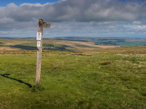
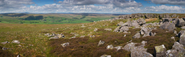
I enjoyed the walk uphill
as the views improved the whole time. At the summit a path signpost
pointed me out across the moor to the NW. There was a faint path to
follow but I wouldn’t call it well used. |
|
|
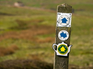
My map showed another path crossing ahead
and as I approached I could see the marker post. It had the tea-pot
symbol (tea trail) to show the way. |
|
|
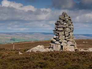
I turned right and
followed it towards Scum Hill but before the summit turned to the left
to investigate some nice stone curricks (tall cairns) amongst a rocky
outcrop. With no path of any kind to follow I kept as near as I could to
the flat ridge along the high point. |
|
|
It was heather underfoot but not
too deep and so not difficult to cross. I crossed Blackway Head and on
to Fullo Currick where the ground became mixed with easier stretches.
Through my binoculars I could see my next objective, the trig post on
Brownley Hill and Kevelin Moor. It was still over a mile away but with
nice weather I enjoyed the crossing. At a dip I came across a couple of
sit down benches made out of old wooden railway sleepers. I took the
opportunity to try one out. It worked well. As I started the gentle
climb of Kevelin Moor towards the Brownley Hill trig post I noticed a
pickup truck in the distance to my left. |
|
|
|
|
I couldn’t see anyone around
but thought the binoculars I could see a dog inside. It was nice to see
and hear many snipe and the occasional plover. Around the Brownley Hill
area were a huge number of black headed gulls circling overhead. The
views from the trig post were impressive thanks to the clear weather.
Approaching Greenleycleugh Crags there was a small tarn on my right.
Adjacent was a shooting box with scrub and old trees deliberately placed
about it, making it look more like a hide. A faint path ran along the
top of the crags but they are more like a line of rocky outcrops with no
crag, cliff or drop off anywhere. I headed down towards the road but as
I approached I noticed a line of barbed wire fence had been erected on
my side. I scoured the line through my binoculars to find a way through.
A pickup truck drove slowly along the road as I approached. When I saw a
gate to get through I headed for it. |
|
|
|
Converted Chapel at Throssel Hole |
|
|
The truck stopped
opposite the gate and a man got out. It turned out to be the same truck
I’d seen parked on the moor. The man was a sort of gamekeeper and was
just checking that I wasn’t disturbing the birds. We chatted for a while
and he told me it was mainly people walking dogs on the moors that
caused problems, especially this time of year with nesting birds. The
fence was recently erected by the landowner to keep his sheep off the
road but it seems to have caused problems with grouse getting on the
road side of the fence and being knocked down due to being corralled. I
headed south down the road to the path marker where I wanted to descend
to the lower road and the River West Allen. |
|
|
|
|
Methodist chapel near Carrshield |
|
|
|
|
Primitive Methodist Chapel 1857 |
|
|
I started my descent but even though the path is
shown on the map there is nothing on the ground to say which side of the
wall it is. Neither is there any sign of a path. I managed to find my
way down to the Throssel Hole Buddhist Abbey. At the road is the old
chapel converted to a house. I followed the road through Wolf Cleugh
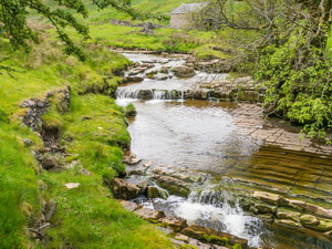
then down another path to the river. My plan was to follow the river
upstream by a path clearly marked on my map. I saw an occasional path
marker but no path. The path was so difficult to follow that after less
than a mile I gave up at the access track to Black Cleugh Farm. I
followed the track up to the road and enjoyed the last few miles along
the road and through Carrshield. It was still sunny and the weather had
warmed up nicely. There was hardly any traffic on the road. |
|
|
|