|
Urga, Molinginis, Reinigeadal,
Isle of Harris. |
||||
|
OS Grid Ref:
NB 17690 0038 |
||||
|
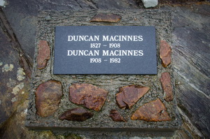
I hadn’t gone far up the
trail when I came to a stone marker on the right with the inscription
|
|
|||
|
I had no idea that later in my walk I would find out. It was wet and windy with little to see. I pressed on to the top of the pass marked by a large cairn. Over the top and just before the main path turned to the left was another stone marking the way. Molinginis to the right, Reinigiadal straight on and Urgha where I’d come from. I took the minor path to the right and headed down towards the sea and Molinginis. It was a well engineered road but not quite as good as the main track. |
|
|||
|
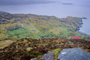
I’d descended a long way before the sea appeared below. Then soon after I could see the outlines of ruined houses and tucked in at the end two with red corrugated roofs. Through a gate was the descent path to the village. After passing the ruins another gate took me to the houses with roofs on. The door was open at the first and inside was a bearded man sitting down and rolling a cigarette. He came out and we chatted. |
|
|||
|
I was intrigued by his reason for being here but after a while still hadn’t understood the reason. He offered me a cup of tea and introduced himself as Seamus. We walked to the next house which was the main dwelling and inside was Simon sat in a comfy chair by a coal fire. I was now even more amazed and very impressed with the interior with bookshelves cosy fire and bottle gas supplying modern amenities. The tea arrived and we chatted about the history of the place and many things about the area. Donald Macinnes turned out to be grandfather and grandson who both died of natural causes at about the same spot near the pass summit 74 years apart. The younger had been the postman and Simon had known him. |
|
|||
|
In the late 1800s the settlement had a population of over 40 and in 1914 a school was built. The outline of the ruin still exists and houses the gas bottles for Seamus & Simon. My plan was to follow a path shown on the map above the coastline. Simon advised against it because of its exposure and poor state in places. |
|
|||
|
||||
|
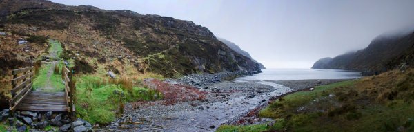
I told him I’d go that way but return if there was a problem. He was right about it being eroded and one point a river had to be crosses which was quite slippery and needed some scrambling. Eventually I saw the head of the bay through the mist and continuation of the main path to Rheinigidale on the far side. Over a wooden footbridge I continued up, taking a short detour before joining the main path. It was a steady climb and then a fairly steep descent before the next set of ruins appeared. Most were the house outlines as low walls but one in particular stood out. All that was left were two full height chimney stacks of brick and concrete. A concrete floor separated them. Around were bits of corrugated iron so I’m sure the building was relatively new compared to the others and mostly made of corrugated iron sheets. |
|
|||
|
Further down and not much above the waterline were the outlines of two stone buildings. They were just walls and nowhere near ready to put a roof on. They were also relatively new structures and probably only a few years old. The rain continued and it was difficult getting pictures without getting the camera wet. I’d seen a few people on the main path and as I returned I saw of them again presumably doing an opposite way out and home. At the wooden bridge at the head of the bay I started the steep climb up the main path that I’d bypassed before. They were straight lengths of zig zag but quite steep. The thick mist continued over the summit and back to the car. |
|
|||
|
|
||||