|
Yad Moss, Burnhope Seat, Nag's
Head, Perry's Dam, Cumbria/County Durham |
||
|
OS Grid Ref: NY 7713 3770 |
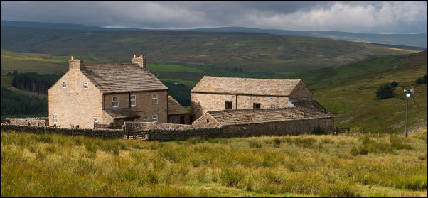
 Yad Moss building and ski tow |
|
|
Mine was the only car there as I left and headed up the side of the
small river to a collection of ski-tow buildings including a sign
saying: |
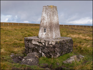 Burnhope trig post |
|
|
The fence line runs to the summit where a short way to the east is the trig post built on the top of a low stone pillar. An interesting fact about the short walk from the fence is that it took me from Cumbria into County Durham. I now needed to head north, following the line of the fence to the area called Nag’s Head on the map. That is where my main objective of the walk was. The map shows an ancient cross but I couldn’t find any information about it. It was about 2.5 miles away across rough and pathless moor. The fence ran generally straight but the County boundary didn’t. It took a wavy line route that straddled either side of the fence. Away in the distance I could see the tall cairn on the summit called Dead Stones. The going wasn’t too wet at all and some stretches had lines of wooden pallets set out to form a path above the peat. Apart from the decking there was no sign of a path but I did see the occasional boot print indicating that someone else had been this way. The cairn at Dead Stones was about 3m high. |
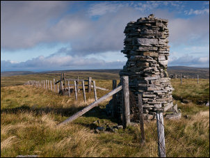 Dead Stones cairn |
|
|
On the other side of the fence was a small stone hut with stone slates and a chimney. It was a delightful little structure with a tiny fireplace inside below the chimney. Someone had put some wood in and tried to light it. The wood was still there and only scorched round the edges indication that the fire was a failure. The door had long since gone but a stone wall in front kept the wind out. I continued north along the wire fence to Hag’s Head. Down to the left I could see the reservoir behind Perry’s Dam. At Nag’s Head the wire fence became a stone wall. |
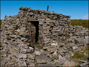 Stone hut below Dead Stones |
|
|
I followed it to the NE then left it to turn NW across open moor. There was no path of any kind as I headed for the co-ordinates of the cross that I’d taken from the map. I had no idea what to expect but as the ground began to fall away I saw a natural stone slab in front of me with a small stone cross and two small pillars either side. They were set into the flat rock and the small cross seemed to have been damaged and repaired. It was very eroded and didn’t have any marking to indicate its age.
|
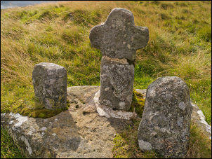 Cross between Nag's Head and Nenthead |
|
|
|
||
|
I left it behind and turned to the SW to join the fence line down to Perry’s Dam. Along the line of the fence were several square stone boundary markers with letters cut in. At the dam was a stoned area connecting to the access track. I followed it to where it joined the track over the pass from Nenthead then turned left and followed the track SW to the buildings of Priorsdale. The road became tarmac and the map shows it as an official highway. Ashgill Wood was below but there had been extensive felling of the pines making the landscape look like a battle scene. Within a mile I’d rejoined the B6277 where I turned left to walk the couple of miles back to the car. It was interesting to note the milestones by the road which all seemed to be in place. Back at the lay bye there were now several cars as well as mine. |
||