|
Winster, Wensley, Snitterton
Hall, Bonsall Moor, Matlock, Derbyshire.Durham. |
|
|
|
 Lead Ore House |
|
Before returning to Winster I turned right along a grassy Limestone Way to the east. It was a pleasant walk between low walls. I wanted to check out the area called Luntor Rocks on the map, but couldn’t find much of interest. A path to the north west descended to Winster were it took an interesting route between buildings which I would never have found from the other direction. In the village I came to the wonderful Winster Market House which dates back to around 1700. |
 Winster Market House |
|
|
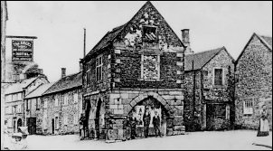 Winster Market House c 1910 |
|
Its purpose was for buying and selling goods during the prosperous era of the lead mining industry in the area. I headed east along the B5057 and at the School found a public car park. I soon left the road through a stile to the left and headed down the valley through fields until I came to a footbridge over the small river. The valley bottom was dense trees and bushes though Clough Wood. Over a small footbridge to the right I headed steeply up thorough Cambridge Wood and into open fields. At the top of the hill I came to the familiar profile of a water supply reservoir. The unusual thing was the grass around it was neatly mown. The path went across the access track and as I glanced left the mystery was solved. A man was there tending some foliage and the whole of the SE face of the reservoir could be seen as having been converted to a domestic house. The man wasn’t the owner but knew him. |
 Reservoir conversion |
|
I descended to the B5057 in Wensley, turned left and headed for the right branch turn towards Snitterton. I soon left it then went through a gate tied up with string and headed up the small hill of Crossgreen to the summit trig post. |
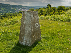 Crossgreen summit trig post |
|
There was a path continuing along the summit ridge but I didn’t follow it as no path was shown on the map. I descended to the north and followed a public footpath through fields to Oker then up the road to Snitterton Hall. The hall is mostly hidden behind a huge surrounding wall. However, when I got to the main entrance the main gate was open and another gate nearby gave views of the garden and hall though its railings. I poked the camera though to take a photo of the beautiful building and magnificently manicured garden. |
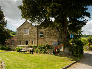 Snitterton village green |
 The magnificent Snitterton Hall I don’t think I’ve ever seen such a magnificent building in private ownership. |
|
|
I passed the farm next to the hall and up the track where the footpath sign pointed. I kept to the track but that was a mistake as the footpath soon turned off to the right and I missed the turn. It turned out not to be a problem as the track took me to Leawood Cottage where a path crossed fields and through Jughole Wood and on to the road. I soon rejoined my planned route and headed up the rough track of Moorlands Lane. I turned right to follow the path called the Limestone Way. It crossed several fields to Blackelow Lane were I headed up the walled track to Bonsall Moor. My next objective was the trig post on Blakelow Hill. At the end of the track there wasn’t a gate so I had to carefully step over a wire fence to get to the field and the summit. Then I turned south and into the area of abandoned mine workings called Beans and Bacon Mine. The whole area as a jumble of humps and bumps of the old lead mine workings. It is a English Heritage site of importance and has a national monument number of 29967. I joined the public footpath to Bonsallmoor Lane then across fields to Bonsall Lane and down to the busy B5055 and the car. |
 Trig post on Blakelow Hill |
|
|
|
|
|
|
