|
Dockray, Little Mell Fell, Great
Mell Fell, Cumbria |
|
|
NY 3929 2152 |
 Colourful sky on the way to Dockray |
|
|
 Royal Hotel, Dockray |
|
The track to the west of Gowbarrow Fell had a thin coating of snow on it, mostly blown in by the wind. Further along there was some drifting but nothing to cause problems. I joined the minor road at Ulcar Row and followed it for the next mile. Like the path it was partly covered with wind blown snow and some areas had drifting which could cause problems for cars. I reached a gate and access to the path that runs along the base of the south side of Little Mell Fell. I wanted to go up the fell and even though the map doesn’t show a path there is one. |
 Near Ulcat Row |
|
|
 Little Mell Fell summit trig point |
|
It climbed diagonally but didn’t seem to be heading for the summit, so I made my own way there. It’s a trig point but with the low cloud I didn’t get much of a view of Ullswater. I then headed west to find a descent route. As I started down I came to one of those impenetrable barriers of thick gorse. I’m puzzled why landowners allow such things as they can’t support grazing for their animals and would be better burnt off. Luckily I found a stile over the fence and then a track down to the road. |
 Wintry weather on Great Mell Fell |
|
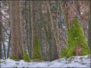
Across was the path that passed Greenrow, through fields to a footbridge across Blackdike Beck. There were two paths to choose from so I took the one around Brownrigg Farm. It was back to the road for a short while then up a track towards Great Mell Fell. There wasn’t an ascent path shown on the map but there was on the ground. I took it upwards, steep at first then easing off though trees and in to the mist. Great Mell Fell is higher that Little Mell Fell yet doesn’t have a trig point. |
 Summit of Great Mell Fell |
|
There is an ancient hump that the map calls a tumulus but I’m not convinced. I continued over the summit to the west and started a steep descent. After a while I took a more diagonal route to join a track around the base of the fell. I continued along it a bit further than I’d planned and had to cross a fence and head back for a while to investigate the ruins of Racy Cottage. Further down the fell I joined the old track which was difficult in places due to sheet ice across it. At the right turn there were some machines working on fixing fence posts. The operator was sat in his vehicle, presumably having his lunch. |
 Matterdale Church |
|
The track back to the road was very rough and wet but the frozen ground helped. I reached the road and headed back towards Dockray. On the way I called at Matterdale Church to have a look round. It’s an interesting church and apparently dates from around 1570. |
 Matterdale Church interior |
|
|
|