|
Whitbarrow Scar, Cartmell Fell,
Witherslack, Cumbria. |
|
|
SD 4406 8287 |
 The path through Buckhouse Wood |
|
Further along the track I saw a ‘permissive path’ sign heading up to the left. I took it and was pleasantly surprised to see that it had stone edgings and was in good condition. It was shown on my map but as I got higher I hoped to find another path going straight up the hillside. I couldn’t find one so had to head straight up through the trees on a steep climb to a wall. It was here that I came across a muddy path which wasn’t shown on the map. |
 Misty walk up Whitbarrow Scar |
|
I was only at an altitude
of 150m but soon headed into low cloud as I followed a very muddy path
up towards the Whitbarrow Scar summit. The path became less muddy and
was easy to follow but with no visibility I just pressed on to the
summit cairn which is a memorial and has inscribed on a stone tablet: |
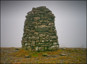 Memorial cairn on Whitbarrow Scar |
|
It was here that I saw a lone runner coming up through the mist. She reached the cairn and continued without stopping. I turned left and began the descent to the west. The path was firm underfoot at the start but as I got down to the trees became very muddy. Across a football field I crossed another field to the road at Witherslack Hall School. |
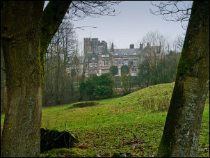 Witherslack Hall School |
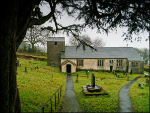 St Anthony's Church Carmel Fell |
 St Anthony's Church Carmel Fell |
|
The road headed north through Low Park Wood to Pool Bank where I left it to turn left along a muddy track. I was heading for a footbridge over the River Winster and was concerned that it may not be accessible because if recent rain. Fortunately the bridge was there and fully accessible from both sides. The field on the west bank was very wet and parts were underwater. At the road I crossed over then walked past Swallow Mire Farm, along another track to the road at Cartmell Fell. I took another track so that I could approach the Church of St Anthony’s through the rear gate. |
 The baptistry containing a plain round font dated 1712 |
|
This is the first time I’ve visited this hidden gem and was surprised to see how old it was. Inside the lights came on automatically and I had a pleasant wander round the early 16th century church. I left through the main front Lych Gate, which is a memorial to the men who died in the Great War. The hall on the left used to be the local School but it closed in the early 70s. I followed tracks and woodland paths to Thorphinsty Hall where I joined Tarn Green Road. |
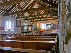 St Anthony's Church interior |
|
It was a pleasant change
being on solid ground. I stopped briefly to have a look at the old
waterwheel at Low Tarn Green. I pressed on to Holme Road and turned left
to reach Bleacrag Bridge over the River Winster. On the bridge is a
boundary stone showing the old boundary between Lancashire and
Westmoreland. The interesting thing to note is the different spelling of
the bridge name. The stone reads as follows: |
 Old waterwheel at Low Tarn Green |
|
|
|