|
Great Ormside, Rutter Force,
Appleby-in-Westmorland, River Eden, Cumbria. |
|
|
NY 6919 1647 |
|
 Waterfall on Hoff Beck and Rutter Mill |
|
|
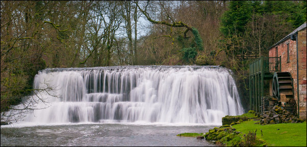
I set off SW along the lane to Porch Cottage. That’s the name on the map but on the house is the name ‘Donkey’s Nest’. Opposite is the path across a couple of fields to Broadmire Road. The last half of the path was incredibly wet and I pitied the sheep in the field who were sinking in the mud and covered in it half way up their bodies. I was very glad to reach the lane and have some easy walking for a while. Turning left then right I descended to Rutter Mill where there is a waterfall, ford and thankfully a footbridge. The footbridge gives a very good view of the falls and adjacent converted watermill. The wheel has been restored and the mill converted to holiday cottages. There was nobody about and I would have liked to get closer to take more photos but signs said it was all private and no public access. So I left the empty buildings to their privacy and continued up the lane for a short distance before leaving it to follow a footpath sign to the right. |
|
|
I then started to follow the west bank of Hoff Beck. The interesting thing is that the river runs north and later in my walk I would be following the River Eden which flows south just a mile to the east. What happens is that Hoff Beck joins the River Eden close to Appleby. Across a couple of fields I came to a footbridge across the river. The far bank was very wet but further along near Low Rutter the going became easier. Approaching Hoff I crossed the river again by a footbridge but the east side of the abutment was very eroded by the river and will soon need a lot of work doing before it is washed away. Along a narrow lane I reached Hoff and crossed the main B6260 to continue along the west bank of Hoff Beck. In the area called Cuddling Hole the path had been washed away and I had a muddy climb back up to the field. |
 Muddy and collapsing path at Cudding Hole |
|
Further on a descent through trees took me to a field and Bandley Bridge, which is a footbridge. A brief ray of sunshine broke through but soon vanished. Over the footbridge the path markings vanish. I passed an area called Rachel’s Wood then steeply up to another terribly wet field. Over the summit Appleby came in to view and I descended along a lane bounded by hedges. It was even wetter than the fields and in places I was just wading through mud. I reached the road and turned right. There was a newish housing estate and I wanted to reach a path high above the riverbank to the north. |
 Sunshine at Bandley Bridge |
|
I turned left along Margaret’s Way hoping that there would be a link path. There was no path sign of any kind so I wasn’t hopeful. Just on the bend I noticed a narrow fenced way and looking down it saw that it connected to the path. There was no sign indicating its existence. I followed the path down into the town to join Holme Street and Chapel Street. I had a look in the Church of St Lawrence then headed up Boroughgate to have a look in the Almshouses founded in 1651 by Lady Anne Clifford. |
 Parish Church of St Lawrence Appleby in Westmorland |
|
The annoying thing is that I wasn’t aware that the tomb of Lady Anne Clifford is in St Lawrence’s Church but the good thing about that is that it’s a good excuse to re-visit it. At the top of Boroughgate is Appleby Castle which is in a sorry state and not open to the public. |
 Almshouse founded in 1651 by Lady Anne Clifford. |
 Wide view of the Almshouses |
|
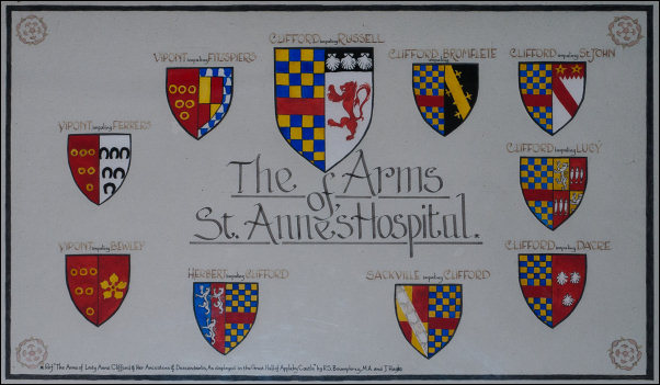 The Arms of St Anne's Hospital. |
|
|
I walked along the road then down a lane to the south side of the castle and the River Eden. A footbridge crossed leading to Bongate Mill which is a 18th century grade 2 listed building. I didn’t cross the bridge as my way was along the west bank of the river to head south. |
 Appleby view looking down Boroughgate |
|
The path was even wetter than those I’d previously walked along and at times I had to make a detour along a high bank to the right. After crossing a large field I entered a very muddy area though trees and the muddy path continued all the way to Jeremy Gill. After crossing under the Settle – Carlisle Railway I followed a lane into the village of Great Ormside. To my left I noticed a small church on a hill and a large tree surrounded with large stone steps. I wandered over to investigate the interesting Church of St James which dates from around the 10th Century. I walked back through the village, passing the large caravan park to my left and back to my car. |
 Church of St James, Ormside. |
 Wide view of St James' Church interior. |
|
 In the graveyard of St James' is this interesting headstone with a crooked cross carved on the top. |
 A sycamore tree growing out of the centre of a flight of steps. It is thought to replace a previous preaching cross. |
| On the drive home I joined the M6 motorway at Penrith so I could have a look at the Countess Pillar. It is a monument erected by Lady Anne Clifford in 1656 to commemorate her last farewell to her Mother, Margaret Clifford, who died in 1616. | |
 The Countess Pillar |
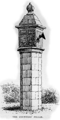 The Countess Pillar from an old guide book |
 |
 |
|
THIS PILLAR WAS ERECTED, ANNO 1656, BY THE RIGHT HON. ANN COUNTESS DOWAGER OF PEMBROKE, AND SOLE HEIR OF THE RIGHT HONOURABLE GEORGE, EARL OF CUMBERLAND ETC., FOR A MEMORIAL OF HER LAST PARTING IN THIS PLACE. WITH HER GOOD AND PIOUS MOTHER, THE RIGHT HONOURABLE MARGARET COUNTESS DOWAGER OF CUMBERLAND, THE SECOND OF APRIL, 1616. IN MEMORY WHEREOF SHE ALSO LEFT AN ANNUITY OF FOUR POUNDS TO BE DISTRIBUTED TO THE POOR WITHIN THIS PARISH OF BROUGHAM, EVERY SECOND DAY OF APRIL FOR EVER UPON THIS STONE TABLE. LAUS DEO. |
|
|
|
 Lady Anne's mother Margaret Clifford in 1586 |
|
|
|
