|
Kirkland, Blancarn, Milburn, New
Greuve mine, Little Dun Fell. |
|
|
NY 6506 3257 |
 Stone-art by Kirkland Hall |
|
As I walked along the Ranbeck Farm access road I had brief views of the distant Lake District fells and a little sunshine in the distance. I reached the isolated house of Wythwaite then turned right along the rough track towards Cringle Moor. |
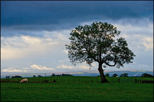 View from Baron's Hill |
|
The first part of the track was completely under water and I had to do a balancing act of walking along the top of the wall to get across the shallow valley. The rest of the track across Stubmire Moor to Blancarn was still very wet but passable. |
 Wet track across Cringle Moor |
|
In Blencarn village I reached the road and followed it SE to Milburn. It is narrow and I had to stand close by the walls or hedges as a few vehicles passed by. Some sections had a lot of standing water indicating recent rain. Milburn is interesting as the central village green area has three roads running parallel. I walked through the village along the left track and noticed a well in one of the front gardens. It was capped with a small stone enclosure with a winding handle for the bucket. |
 Flooded road near Milburn |
|
The odd thing is that the modern map doesn’t show it but the old map does. I left the village along Fell Lane then the rain started. I stopped to put on all my waterproofs as it looked as though it was set in for most of the day. After an old stone barn called Windy Hall I was out on the open moor. The map shows a track heading towards the NE but it was difficult to find at first. It was little more than a slight raised ridge and many sections were in deep standing water, meaning long detours to get round. At Mudgill Syke I watched a cow wade along the track and could see that it was far too deep for me to wade across. |
 A Milburn house. Helm isn't a place but a local wind. I'm not sure how you could view it. |
|
Fortunately there was an adjacent wall so I had to do another balancing act and walk along the top of the wall. My first objective of the day was to visit an old mine level adjacent to Middle Tongue Beck. When I got to the beck it was swollen with the recent rains and too deep and wide to get across. I carried on up the beck and hoped that I could get across at the mine. I saw the spoil heap up ahead and when I got there just managed to jump across without incident. The ruined mine buildings had been quite large and the tunnel entrance going into the hillside was still open but a metal grill had been fixed just inside. |
 Spoil heap for the mine |
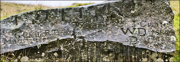 Locally known as the Grave Stone |
|
|
By now the rain was
torrential so it was difficult taking pictures without getting the
camera wet. As I wandered round the ruin I noticed a large boulder on
the hillside with names chiselled into it. This was not modern graffiti
as the dates by the names were 1884 and 1885. It was difficult to read
all the text in the rain. Along the top of the rock was a series of old
shot blasting holes indicating the rock had been split to provide a
fairly flat face for the chiselling, I could read the following: |
 Mine entrance |
|
I continued up the north side of the beck but it was now much steeper and more of a scramble in places. The beck was now far below in a deep ravine but with the rain and cloud I couldn’t see anything else. I came to another smaller mine level with a much smaller ruin next to it. The mine entrance had been collapsed for many years and hardly any evidence of its existence remains. Heading across the high fell to join the main path was incredibly wet underfoot and the wind and rain made the going uncomfortable, especially as the temperature had dropped to 3degC. I reached the path which is also the Pennine Way. It is made up of a series of old stone flags which made the going on the flat much easier. As I headed up the slope of Little Dun Fell I had to leave the slabs as they were very slippery in the rain. Over Little Dun Fell I descended to Crowdundle Head. The path is still stone slabs on the descent but just as slippery so had to be avoided. On the climb to Cross Fell the path is crossed by the Teesdale to Kirkland path which is the one I wanted. The position is marked with a nice cross chiselled into the stone slab. I couldn’t take a photo because of the wind and rain. Crossing the fell to Wildboar Scar was incredibly wet but eventually I descended below the cloud and could see where I was going. There is a nice green track descending Wildboar Scar which looks nice and easy but in the wet was very slippery in places. The track continues past Grumply Hill and on to cross Littledale Beck and on to Wythwaite. As I waslked back to Kirkland along the track I was astonished at the amount of water running across the tarmac. At Ranbeck Farm the track was completely submerged. I was glad to get back to the car and change into dry clothing. |
|
|
|
|