|
Elterwater, Stickle Ghyll,
Stickle Tarn, Castle How, Cumbria |
|
|
NY 3291 0509 |
 Baysbrown Wood |
|
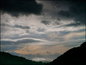
The weather was overcast but when I emerged into open ground I had a moody view of Pike of Stickle ahead with swirling clouds. At Side House the map shows a path which isn’t visible on the ground so I took the obvious route over a footbridge and along the farm access track. At the main Langdale road I turned right then left up the access to the New Dungeon Ghyll Hotel. |
 First view of the Langdales |
|
The path after the hotel branched left and right with no indication which way each went. I headed to the Millbeck buildings then started on the main path up the east side of Stickle Ghyll. |
 Moody sky from Millbeck |
|
The map shows the main path up the opposite bank but the one I was on was the best made and most used. Stone gravel at first became placed stone steps as the gradient increased. Approaching Stickle Tarn dam the path crosses the Ghyll by large stepping stones and soon reaches the dam. The weather continued overcast and the wind started to increases. |
 Langdale valley bottom |
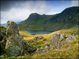
 Looking across Stickle Tarn to Pavey Ark |
|
|
Across the tarn is the imposing rock face of Pavey Ark and the interesting diagonal, and steep in places, path of Jack’s Rake. Its many years since I’ve been up there and must return sometime. I left Stickle Tarn by a path to the east. The paths now are generally indistinct but I was heading up towards Blea Rigg and had good visibility. On Blea Rigg the views were nice even if overcast and cloudy. The path to the east is split in several places and still mostly indistinct. |
 Stickle Tarn from Blea Rigg |
|
I’d already seen a few people at a distance but now more were coming up the trail. I’m happy to acknowledge people with a ‘good morning’ but I get annoyed with daft questions. One couple asked me if I’d come from Stickle Tarn. When I said I had they asked how long it would take them to get there. “Depends how fast you walk” I replied. On Little Castle How I visited a camp I’d used many years ago. It is in a superb position for views if the weather is clear. I continued to Dow Bank and planned to descend via a path shown on the map. |
 Military manoeuvres |
|
I started the descent but found there was no sign of a path of any kind. It is clearly shown on the 25K map and illustrated a major error in the Ordnance Survey’s policy of not updating paths, though roads are done eventually. Before descending into the impenetrable ferns and thorns I traversed along a sheep track by Huntingstile Crag to join the main path. On the road I soon got back to the car park which was now full. |
 Military manoeuvres |
|
|
|