|
Blackden Moor, Edale Moor,
Kinder Scout, Derbyshire |
|
|
SK 1151 9025 |
|
|
I’d previously checked Google Earth to find somewhere to park and found what I thought was a small car park by the River Ashop. When I got there I found it wasn’t a car park and a notice on the gate said ‘Farm Vehicles Only’. Fortunately there was a lay-bye on the road a short way back towards Glossop. It was just coming light when I set off and the first obstacle I hadn’t planned for was the crossing of the River Ashop. It was a ford and even though it was shallow it was just too deep for my boots. No problem, boots off and a quick wade across. |
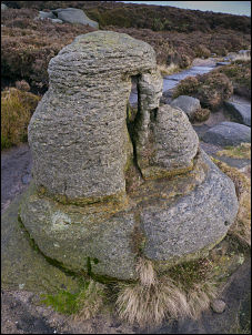
 Rocks on Blackden Moor |
|
A track headed diagonally up to the SE and had been used by quad bikes. It was an easy and steady climb to the side of Gate Side Clough where the track downgraded to a path and headed straight up to Blackden Moor. The climb was easy but it got windier as I reached the summit. A gale was blowing on the summit but for a time it was on my back making the going easier. My last walk was along the west side of Kinder Scout and this is my first visit to the east side. Today I plan to do a clock-wise circuit. |
 Rock on Nether Tor |
|
There was a lot of cloud blowing about and I couldn’t see much ahead, though there were still views down into Woodlands Valley. At the start the path along Blackden Edge was fairly good but soon began to deteriorate in places. Deep and black quagmire soon became very frequent. The weather was against me and I couldn’t see far across the moor. Many interesting rocky outcrops were beside the path but looked dull against the misty background. There were no signs and the correct way ahead wasn’t obvious. On Crocksone Out Moor the main path turned south to head for Madwoman’s Stones but I wanted to continue east to Crookstone Knoll. I finished up crossing a patch of off-path heathery ground to regain the correct path. I soon reached the easternmost point of my walk and turned SW to start the path along the southern side of Kinder Scout. |
 View down to Edale |
|
The views changed dramatically and I was now looking down on the more interesting Vale of Edale with Mam Tor on the far side. The path on this side of the Scout is generally better and long lengths have been paved with imported slabs of stone. A few people were about but they were mostly solo walkers. In the area of Pym Chair the path degenerates to impenetrable black slushy bog again and I made wide detours to get by. I reached the feature called Swine’s Back where I turned sharp right to head north. The map shows ‘Edale Cross’ a short way to the south but I didn’t make a detour to investigate. |
 South view from Hartshorn |
|
I was soon back in cloud but at least it was easy to follow the path which was of the paving slabs I’d seen earlier. On Kinder Low the path vanishes as it crosses a stony featureless area. I saw the trig post through the mist and went over to investigate. A few small cairns marked the continuing path which became more distinct as I reached Kinder Downfall, a deep gorge and waterfall. The perimeter path continued along the plateau edge but I decided to follow a more interesting looking path which headed up the river feeding the downfall waterfall. I was still in mist but the side of the wide and shallow river bed made a refreshing change from the terrain I’d been on. I was heading back to the north side of the Scout and knew the riverside path would only take me part of the way. |
 Rocks above Grindsbrook Clough |
 Rock outcrop by Crowden Clough |
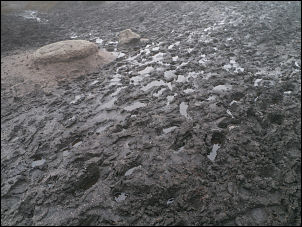 Black squelchy bog |
|
At some point I’d have to leave it and head across open ground to rejoin the main path to the south of Fairbrook Naze. It was a pleasant surprise to find the ground was generally firm and easy to find a route through the low tussocks. Several lines of boot prints showed that others had been this way as well. It didn’t take long to reach the feeder stream for Fair Brook and I followed it to where it met the main path. I decided to follow the main path down the gorge of Fair Brook which was steep at first but soon levelled off to a pleasant riverside walk. I was back in Woodlands Valley and when I reached the River Ashop found that the map showed a footbridge a short distance to the north. I passed the ford that I’d waded across earlier and followed the bank to the bridge. On the far bank a nice path lead through pine trees and back to the Snake Pass road. It was nice to see that it brought me out almost opposite my car. |
 Trig post on Kinder Low |
|
|
|