|
Bampton, Measand End, High
Raise, Cawdale, Cumbria. |
|
|
NY 4977 1831 |
 Bampton shop and Post Office |
 Always Open ..within reason |
Next to the bus shelter
is a telephone box which I always stop to look at as I pass as it was
used in a scene from the film ‘Withnail and I’. In Bampton the small
shop and post office was open even though the sign said it didn’t open
till 9am. It was 8:15 as I passed. Another surprise was the small Bridge
End Garage and old fashioned analogue fuel pumps. Another interesting
feature was the Mardale Inn which said on a sign |
 Woodland at Hunger Hill |
|
|
Through the 2 gates I was on the open fell and took a wandering route SW then west to Four Stones Hill. There was a nice view of Haweswater and cairn but it was rather hazy and windy. I soon joined the track down to the wooden footbridge at Fordingdale Bottom. The path across to the base of the Measand End climb wasn’t obvious and at times I was wading through the dreaded ferns. Once on the ascending track it was an enjoyable climb which has a steady gradient. Walking up Long Grain it was still hazy so I pressed on to the large cairn at Low Raise then on to High Raise. I then headed north along High Street and the views seemed slightly clearer. At Keasgill Head there is a branch path which heads east towards High Kop. |
 Four Stones Hill cairn and Haweswater |
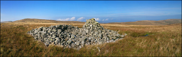 wide view of Low Raise cairn looking north |
|
 the footbridge below Towtop |
The annoying thing is that it’s not shown on the map. I followed it along to Low Kop. The map shows a path coming from Wether Hill to High Kop then Low Kop; it doesn’t exist on the ground. From Low Kop there are 2 descent options so I took the NE one along the ridge then down The Hause between two plantations of Pines. At Hause End is a nice view of Towtop and the path across it. I headed across to Towtop Kirk and not the path shown on the map which crosses Cawdale Beck by a ford which has to be waded. At Towtop Kirk is a circular feature which doesn’t seem to have been a stone circle, just an ancient earth bank. From here it is a short walk to the NE to Cawdale Beck and a wonderful stone footbridge. There is no path connecting it to the road at Moorahill Farm but it’s only a short walk across rushy land. I reached the road and had a short walk back to the car. With the weather being so nice it was astonishing that I hadn’t seen a single person all day. |
|
|
|