|
Keld, Rogan's Seat, High Frith,
Yorkshire. |
|
|
NY 8922 0121 |
 parking charges |
 East Gill Force waterfall |
|
 Crackpot Hall |
I reached the small settlement of Keld which is off the through road and down a narrow lane. There was a large car park which seems to be run by the farmer. An honesty box asks for £1 or £2 for all day to park. I was happy to pay the £2 charge. I left the houses and headed down Keld Lane, which is a path. I soon came to a junction and took the left branch down to the bridge over the River Swale. On the far bank I came to East Gill Force waterfall but instead of following the track round to the left walked on the grassy area by the base of the fall. It’s a delightful spot and I remember over 30 years ago (Fri 16 May 1980) walking across the same patch of grass as I walked the Wainwright’s route of the Coast to Coast path with Charlie. I rejoined the track and continued east towards Crackpot Hall. |
 Crackpot Hall when occupied |
|
|
The building has been a ruin for many years but there is still enough left the show the fireplaces and even a tin bath. Further up the track is another building, this time still with its roof on. The track then narrowed as it passed below Buzzard Scar but this must have been due to erosion as it became more substantial on the far side of the scree. At Swinner Gill is a nice stone bridge then a short climb to the ruined Lead Mine buildings. A path continued up by East Gran beck which was a bit of a scramble in places before joining a substantial track which goes over Lownathwaite to Gunnerside Beck. |
 Coast ot Coast marker |
 Frith Tarn |
I wasn’t going that far as another stoned track heads north to Rogan’s Seat. As I walked along the track I could hear and see shooters in the distance on the far side of Gunnerside Gill. Thankfully there were none in this area. I passed a new shooting hut on my left and continued to the indistinct summit of Rogan’s Seat. I left the track to reach a small pile of stones which may have been the geographic summit then returned to the track. Over the summit the map shows a shooting hut where I’d planned to have my lunch but when I got there all signs of it had gone. The track ended and I followed shooting butts down to Candleseave Sike where I found a nice rock to sit on and eat my sandwiches. I hopped across the stream and followed a quad bike track up the fell side for a while then continued by the stream to Frith Tarn. |
|
|
 Eurofighter passing bye |
|
After the tarn the ground was quite firm and easy to walk on. I saw the large cairn by Frith Quarry and headed for it. It was worth a stop to take in the views to the west. It was overcast with some low cloud but still worth a look. I even managed to get a couple of snaps of a Eurofighter jet out on a training flight. Below me was the house of High Frith which still had its roof on. |
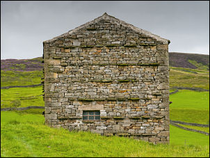
 High Frith Farm |
 High Frith Farm interior |
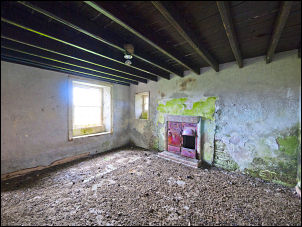 High Frith Farm interior |
|
I had to check it out and was amazed how well it had survived. There was no sign of an access track so I don’t know how long it was since last occupied. Inside all the rooms were there, including the bedrooms. I descended to the main track below which is also the Pennine Way. Continuing south I returned to Swaledale and great views down to Keld. When I’d returned to East Gill Force waterfall a group of painters were there. Unfortunately they were just packing up their stuff so I didn’t get chance to see their work. |
 Keld Scar barn |
 Keld Scar barn and 1687 date stone |
Returning along Keld Lane a lady was doing a nice watercolour of Keld Scar barn, but she too was just packing her stuff away. Back in Keld I returned to my car but made a brief call in to the information centre which had some nice pictures on display. |
|
|
 Keld Chapel and Manse c1905 |
|
|
|
|
|
|

