|
Moffat Dale, Carrifrans Gans,
White Coomb, Frithybrig Head, Loch Skeen, Dumfries & Galloway |
|
|
NT 1863 1444 |
|
|
|
|
|
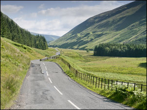
I visited his grave and paid my respects then continued along Moffat Dale to the start of my walk. I was last here on the 21 June 2011 in gloomy and rainy conditions. Today it is sunny and clear. I started where the Grey’s Mare Waterfall tumbles from the hill. The official car park had to be paid for but across the road is a very wide and firm verge, which is free. I had a couple of miles of walking back along the A708. It was very pleasant in the warm morning sunshine. A car approached and the window opened. I assumed they would be asking for directions but I was pleasantly surprised to be offered a lift. I politely declined. Shortly after Polmoodie I reached the cattle grid and the point where I was to leave the road and head uphill. |
 looking up Moffat Dale |
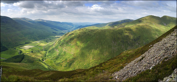 Moffatdale and Saddle Yoke from Carrifran Gans |
|
 small cairn of Carrifran Gans |
I could see the steep climb up the ridge to Dun Knowe and Carrifran Gans. A stile appeared to indicate a path but once over it any sign of a path soon vanished. I crossed the wall and headed steeply up through deep ferns but thankfully there was a good wire fence to give me occasional handholds. The last time I was here I descended this route, which I don’t recommend. Although climbing it is steep it presents no particular problems and is a good way to get on the summits by the quickest route. Unfortunately as I reached the summit the early sunshine vanished and an almost complete cloud cover hung overhead. |
|
It was high enough not to obscure the mountains and I still had good views all around. I followed the fence for a while but left it for a track which headed for White Coomb. As I approached the summit I searched out the two ancient cairns which the map shows. I couldn’t find them on my last visit because of mist. I turned west towards Firthhope Rig, following the collapsed wall line along firm ground. At the summit there was enough wall left to shelter behind as I had my sandwiches. Continuing north towards Frithybrig Head I got a wonderful view of Lochcraig Head and its steep south face. Crossing Talla Nick the ground was quite boggy but there was enough wall left to use the stones to hop over and keep my boots dry. |
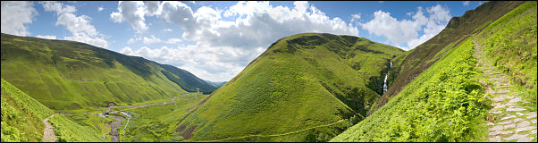
 view to Lochcraig Head and Loch Skeen to the right |
 wide view of Loch Skeen |
|
 wide view (180deg) from the descent path of Grey Mare's Tail waterfall |
|
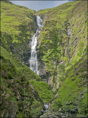 Grey Mare’s Tail waterfall |
At Lochcraig Head I kept to the south to get the best views as I was now looking down on Loch Skeen. I left the small summit cairn and started the steep descent down to the Loch. It was firm underfoot for a while but soon became quite boggy. I followed the wall for as long as I could but had to leave to head for the Loch side. It was quite rough underfoot but a nice path, and tourists, appeared as I got to the Loch. The sun began to re-appear as I started my descent. The path is firm and good underfoot and for a while isn’t too steep. Plenty of people were coming up as I went down and some asked ‘how far to the top’ presumably they meant the Loch. At the top of the Grey Mare’s Tail waterfalls the path becomes much steeper but is well made and stoned so isn’t a problem. I had a good view of the car park below which now had many cars in it. I also saw another path on the opposite side of the valley going a little way up above the river to get a low view of the waterfall. I investigated it and managed to get a different view of the waterfall. It was then a short walk back to the car. |
|
An information board comments on a previous visit by Sir Walter Scott (1771 – 1832) and his comment were that he fell off his horse here: 'the ground gave way, and down went horse and horsemen.. into a slough of peaty mud and black water.' Scott devoted as section of his poem Marmion to the waterfall and scenery. Where deep
deep down, and far within |
|

