|
Dunmail Raise, Brownrigg Well,
Helvellyn, Dollywaggon Pike, Raise Beck, Cumbria.. |
|
|
NY 5295 1115 |
 the Thirlmere Strainer House. For many decades this view was obscured by trees. They were felled about 5 yrears ago. |
 The Union lock that failed to keep me off the fell |
This is where I left the track and headed upwards. A locked gate was my first obstacle but I soon hopped over it. It was amusing to see the name of the lock manufacturer. To keep us out it was called a ‘Union’ lock. It’s a shame the gill doesn’t have a name as it is full of interest all the way up. The first thing to see is the feature known as the wagonway on the map |
|
|
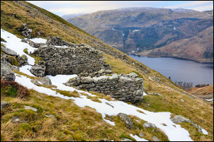 The old mine building |
|
It’s a well engineered gradient probably used to lower wagons of ore. Higher up is an interesting ruined mine building sat in a recess in the steep mountainside. Climbing higher I reached old spoil heaps and found one with a nice flat top to sit and eat an early lunch. There was lots of snow about and it was too cold to hang around for too long. |
 Looking down the unnamed gill to Thirlmere |
 The access to Brownrigg Well |
I plodded steadily upwards across the snow fields until I came to the line of the old leat running from Brownrigg Well. I followed it to the well which is a spring issuing from fell when the ground is clear. Today the whole area is covered in snow and the well is buried. Normally it’s the only source of free running water and is the highest spring in England at an altitude of 868m. The sheep must use it as a hole had been dug down in the snow as they’d tried to get access. |
|
The visibility was now reducing as I entered cloud and by the time I’d reached the Helvellyn trig point I couldn’t see much. The shelter stones were frozen and deserted as I passed. |
 Helvellyn summit trig point |
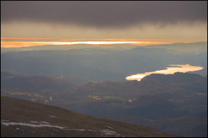 on the descent was this distant view of Windermere and Morecambe Bay |
I headed south and over Nethermost Pike, following the east edge and looking down into the snowy valleys. I joined the main path at Dollywaggon Pike and continued to the metal boundary post where I turned right and followed a minor path directly down to the west side of Grisedale Tarn. |
|
I continued my descent by Raise Beck which was partly iced over in places. It’s a nice interesting descent and returned me to the path at the top of Dunmail Raise. |
 Raise Beck waterfall |
|
|
|
