|
Langden, Langden Castle,
Hawthornthwaite Fell Top, Holdron Moss, Lancashire. |
|
|
SD 6326 5117 |
 Miranda at Langden |
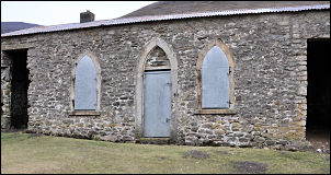 Langden Castle |
I soon left the depressing buildings behind and was heading out into the open valley. After a short wile I came to the Borehole building where water is pumped up from the rock strata below. It isn’t obvious what the building is but nearby are cylindrical rock cores which were drilled out of the ground to allow the pump and pipes to be lowered below the water table. I followed a fairly good estate road up to the area called Holdron Castle, but there is no castle. The track then headed down to Langden Castle, which isn’t a castle but a shooting hut. It’s a stone built and in good condition with the door and windows shuttered and locked. |
|
I continued along the track which then started to head up to Lingy Pits Breast where it came to an abrupt end just before Weasel Clough. An indistinct path continued but I soon lost it. The going wasn’t too bad though and I kept going to Stake Clough then a bit higher to find a hollow with good shelter from the wind. I decided to stop here for my lunch as I wouldn’t find any more shelter once I got on the tops. It was cold and windy and a bit of drizzle in the air. I was only a short way from Dead Man’s Stake Clough and the large scale map shows a point called Dead Man’s Stake. If I’d researched the walk properly I could have investigated and found out if there is anything there, but not today. Crossing Langden Head was fairly rough but as I got on the summit it flattened considerably and large areas had been staked down with some form of rope netting to prevent erosion. |
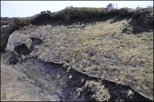 String vest over the bog |
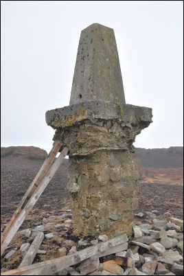 Hawthornthwaite trig Point. |
It looked like some of the worse erosion I’d seen had gone on here. At the trig point on Hawthornthwaite Fell Top the surrounding area was so eroded the trig point was standing on its exposed foundation, which was higher than the original post. I’m surprised it hadn’t fallen over. I started to follow the fence towards Lingy Pits to the SE. The ground was too bad by the fence so I soon picked up a faint quad bike track which wasn’t much better. |
|
The walk across Black Clough Head and Holdron Moss was very wet and extremely tedious. If any walker reads this and hasn’t covered this bit of ground I would suggest you don’t bother. Over the top of Blaze Moss it firmed up a bit as I descended down to the Trough of Bowland Road. I was glad to be on firm ground and enjoyed the easy walk down to Losterdale Brook and Sykes Farm. I few minutes later I was back at the car. |
 Holdron Moss |