|
Bleasdale School, Bleasdale
Moor, Fiendsdale, Fair Snape Fell, Parlick, Lancs. |
|||
|
SD 6003 4437 |
 Parlick from Bleasdale |
||
 Trees and mist at Bleasdale |
He was also a local farmer and was the ideal man to ask about the Post Office. They attempted to sell it as a business many years ago but couldn’t so it finished up as a private house. I took the lane to the north to Bleasdale C of E primary School. I could have turned left here to follow the road but decided to continue north past the St. Eadmer’s Church and on to Admarsh Barn and its 1720 date stone. A footpath heads off to the left but the signs and gates don’t help much to get past the building. It isn’t a barn anymore but a private house. |
||
|
I followed the path across a wet field and clump of trees to rejoin the road at Marles Clough. At Brooks I could see the old pack horse bridge a little further upstream. The access to it from the building had been blocked with tape so I walked along the steep bank of the river to have a closer look. It was quite narrow but had an interesting approach from the east. Later research shows that it isn’t a packhorse bridge as it was built after the 1840s and isn’t on any recognised packhorse route. I continued along the road and saw two children on bikes approaching. At the same time a car approached with children being driven to school. It was interesting to see that the children in the car looked miserable while the two on bike were happy and smiling. |
 The packhorse bridge that isn't. |
||
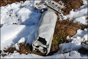 Piece of wreckage on Winny Bank |
Bleasdale Tower House was further along on the left but a high wall along the road meant I couldn’t see anything of it. Before the main road a Stang Yule I took a minor track to the right to enter open land on Oakenclough Fell. There was a reasonable track for a while but when it turned through a gate in to the wooded area to the right the way on was a rougher path which followed the wall side. At the end of the wall and woods I joined another and better track heading up on to Bleasdale Fell. The weather had started to clear a bit and I had a wonderful view to my right of the whole of the Bleasdale area. With an easy gradient it is a very pleasant track to be on. I wanted to check out the trig point so reluctantly had to leave the comfort of the track for much rougher fell. There had been quite a bit of erosion around the trig point pillar over the years and the base is standing proud of the surrounding ground. |
||
|
There was now snow covering the heather making the going uncomfortable and rough. I headed east towards Fiendsdale Head but I had quite a bit of ground to cover before getting there. There was no sign of a path anywhere although I could see the occasional boot print in the snow. Approaching the small rise to Whinny bank I found some old pieces of wreckage which had all the appearances of being from a crashed aircraft. The only reference I can find to a crash near here is of a Blenheim BA246 bomber which crashed in 1944 while on a training exercise. |
|||
|
|||
