|
Bleasdale Circle, Fair Snape
Fell, Parlick, Lancs. |
|
|
SD 5997 4446 |
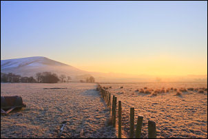 Parlick at sunrise. |
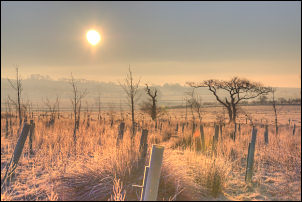 Fields approaching Bleasdale. |
There were no other cars or people around and I’d walked over a mile before I saw the first vehicle. There was a lovely pink glow over the mist and I wondered if the day would clear after sunrise. I continued along the road to Higher Brock Mill where the colour of the morning light continued to improve. The sun had risen as I followed the minor and private track to Bleasdale School. The temperature was still well below zero but the light made it look warm. I was surprised how large the school was and I’m not sure which is the main roadway to it as all roads seem to be private. |
|
On the right seemed to be a local Institute building and an information board for the Bleasdale Circle, then I came to the Church of St Eadmer’s. The original church dates from 1577 and appears to be the only one in England dedicated to Saint Eadmer. The present Church dates from 1835. I stopped in the very tidy graveyard then went inside the church for a look round. Then I continued along the track towards Vicarage Farm then picked up a concessionary path heading across the fields to the Bleasdale Circle. |
 Church of St Eadmer’s, Bleasdale |
 Bleasdale circle in the trees. |
The circle is in the centre of a clump of tree which is fenced off from the surrounding fields. Just inside is an information board but it was totally covered in frost and I had to scrape it all off before I could read what it said. It says the Circle is a Bronze Age timber structure consisting of two circles set within one another. The Circle was discovered in 1898 by Shadrach Jackson and Thomas Kelsall. Excavation of the inner circle revealed posts, poles and a grave. In 1924 the site was scheduled as an Ancient Monument but it was not until 1935 that the outer circle and the area between the circles were excavated. At this time the inner circle posts were replaced by concrete ones. Four of the posts were moved to the Harris Museum, Preston. Passing through the circle there was the remains of a stile at the opposite end. |
|
On the right seemed to be a local Institute building and an information board for the Bleasdale Circle, then I came to the Church of St Eadmer’s. The original church dates from 1577 and appears to be the only one in England dedicated to Saint Eadmer. The present Church dates from 1835. I stopped in the very tidy graveyard then went inside the church for a look round. Then I continued along the track towards Vicarage Farm then picked up a concessionary path heading across the fields to the Bleasdale Circle. |
 Well House, Bleasdale. |
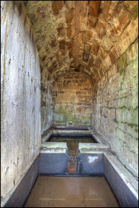 Well House interior. |
I crossed it and headed across fields towards Higher Fair Snape Fell. On the way I noticed a small stone building with a wooden door. I had a look and peeked inside. There were some stone cisterns with clear water in them and it looked like it could be connected with the Church for possible holy water, but I was soon to be proved wrong. I checked the large scale map when I got home and saw it was called ‘Well House’. At Higher Fair Snape Farm I followed a concessionary path through the farm up towards a track climbing Fair Snape Fell. I saw the farmer coming out of one of the buildings and asked him about the small stone building. He said it used to be the source of a water supply to the school. Looking at the lay of the land it didn’t look high enough but checking the map it is 30m higher so would have given a good head of water. I followed the track upwards and soon came to the snow line. |
|
It was fairly thin but had drifted into the depressions which included the track in places. It was an easy climb and got even better as I saw more of the snow covered approach towards Parlick. I was now above the mist and haze and had a wonderful blue sky above me. I wandered over to the trig point on the summit of Fairsnape Fell, there was a young woman there but she left as I approached. I stayed around for a while to take in the view. I had a fairly clear view of Ingleborough 20miles away to the NNE. I retraced my route back for a while then joined the path along Blindhurst Fell ridge. There was a path to the left heading towards Wolf Fell but that will have to wait for anther day. Straight on was the fence leading up to Parlick but I couldn’t see any tracks in the snow so followed another route a bit to the right. It soon joined the fence and I followed it to the summit. Only a pile of stones mark the summit. |
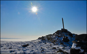 Fair Snape Fell summit. |
 Ingleborough from Fair Snape Fell. |
|
 Waiting for the wind on Parlick |
There were now a few people about and I’m surprised there weren’t more as the weather was superb. The sky above was still blue and below was a sea of mist covering the whole valley below. All I could see sticking out of the mist was Pendle Hill, the Winter Hill transmitter mast and Beacon Fell. Just over the summit I saw two figures sitting down with what looked like huge ruck-sacks. They were just looking out over the sea of mist below. As I approached I realised they were hang gliders. I asked them if the mist was going to a problem for them. They said not but they were waiting in hope for some wind so they could use it to stay up. Otherwise it would be a one way trip down. It was an easy descent back down to the lane but as I got lower a lot more hang gliders were climbing up. At the lane every parking space was now taken up. A considerable contrast to me being the only one when I set off. |