|
Out Fell, Fountains Fell, Coates
Cavern, Yorkshire |
|
|
SD 8480 6805 |
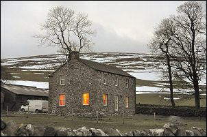 Westside House |
 Path at Henside |
At the next road junction I needed to pick up a path across the fields but the snow had drifted up to the top of the walls and to the top of the gate. Getting over the gate wasn’t a problem as all I had to do was walk over the snow. The recent cold weather was going to cause some problems when the thaw comes. The stone walls were now in an unstable state due to the ice and many will probably collapse when the snow goes. I headed off into the snow in the direction shown on the map. Passing a small old quarry I was in deeper snow and lost all traces of the path. To make matters worse I was soon in cloud and wouldn’t emerge until my walk was almost over. When I reached the wall I followed it up towards Out Fell. This isn’t the way the path goes but I just wanted to check out the trig point. There were a few patches of clear ground but it was very wet after the thaw. The drifts of snow that were left were also very wet and not solid enough to walk on. |
|
I reached the trig point but with no view I didn’t hang around. I wanted to descend and pick up the path towards Tennant Gill but I had to follow a compass bearing through the featureless snow and cloud to find it. The going was getting quite difficult so I decided to keep my altitude and head for the track above Tennant Gill. I eventually reached it but soon lost it in the snow. Every step had to be fought for so instead of heading for the north end of Fountains Fell and the line of the Pennine Way I decided to take the direct route over the top. |
 Out Fell trig point |
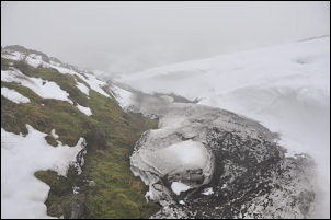 Not much to see on the fell |
It was fairly steep in places but eventually I reached the wall along the summit and was able to find some shelter to have my butties. I then headed off west, descending through horrible wet snow, deep gullies and only cloud to look at. I was heading for an area that I visited many years ago with the caving club. Hammer Pot, Magnetometer Pot, Coronation Pot are all names from the past but I wouldn’t be able to see the entrances in the snow. Approaching the massive sink hole at Coates’ Cavern I slipped badly in the snow and twisted my right ankle. The rest of the walk was a painful hobble. Eventually I reached Fornah Gill but the farm track to Rough Close was little better than the snowy fells. The farm track leading down to the road was drifted up so I walked parallel in the field. At the road I was back on tarmac and soon back to the car. |