|
Cross of Greet, Catlow Fell,
Bowland Knotts, Bowland. |
|
|
SD 7022 5899. |
 Cross of Greet mortise with ice. |
 Ordnance Survey trig point on Bowland Knotts |
Next to it was a large Ordnance Survey bench mark with the top of its original metal pin missing. I turned right to leave the easy walking of the road and head off east across some very wet ground. I tried to follow the fence line but before long I had to climb over it to make a wide diversion to get round a large area of water. The ground was a mix of snow, ice and water and very difficult going. I eventually reached the wall at Crowd Stones, which is just a small rocky outcrop, and used it to shelter from the wind for a quick coffee from my flask. |
|
I continued along the wall to Ravens Castle and thankfully found the ground a bit more solid, though still wet. There was still swirling cloud around so I had no distant views. On a good day this must be an impressive walk as the Yorkshire Dales area away to the NE. The wall is also the boundary between Lancashire and Yorkshire. At ‘Cold Stone’ there was some good shelter behind the wall so I stopped for an early lunch. The rocky outcrops were also a bit more interesting. The crossing of ‘Copy Nook’ was fairly wet but then the ground improved as I climbed towards Bowland Knotts. I climbed over the wall to have a look at the trig point column then wandered through the interesting area of rocky outcrops. |
 Misty Bowland Knotts |
 A wet crossing of Old Moss |
It was quite eerie to suddenly see a vehicle in the distance as I approached the Bowland Knotts Road. I didn’t go as far as the road but turned south to pick up the rough track crossing ‘Old Moss’. The cloud began to thin a bit and by the time I reached Pike Side I was able to see Stocks Reservoir in the distance. I continued descending to the south and at a gate came to open fields where I joined a farm track to the abandoned building of New House. Some wall rebuilding had been done nearby and also what looks like an old well had been rebuilt. |
|
|
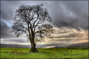 Lonely tree near New House |
|
I had a quick look round
the building before descending to the River Hodder. There was a nice new
footbridge and on the far bank a memorial plaque which said ‘In memory
Of GIL MOORHEAD L.C.C.E.S. 04.10.1936 – 24.06.2008’ |
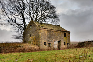 New House, now abandoned |
|
|
I crossed the field to an area called Collyholme. The remains of the original building are still visible and some nice stone slab water troughs. The path heads up by Copped Hill Clough and just before reaching the farm track it is possible to see the line of the old narrow gauge railway which used to link the Stocks Reservoir building project with Jumbles Quarry. The track crossed the Clough by a trestle bridge. Only part of the stone bridge abutments remain. At the farm track I turned right and soon reached the Lyth Fell road where I had a pleasant walk back to the car. |

