|
Dunsop Bridge, Langden Brook,
Fiendsdale Head, Totridge, Bowland. |
|
|
SD 6607 5012: |
|
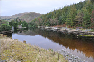 Langden Intake Lagoon |
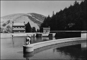 Somewhere behind the trees is this lagoon with the statue of Myranda. She was sculpted by the late George Aldersley who was a Water Engineer at Preston and District Water Board in the 1960s |
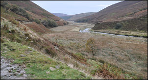 Langden valley from the castle. |
It now had the aura of dereliction about it as there doesn’t seem to be a keeper in residence. The access path continues past trees on the left to a large intake lagoon in Langden brook. I looked along the baffle walls for a statue that I remember used to be here but couldn’t see it. I was concerned that it had been removed but I later found out that it is still there but in a smaller lagoon that is hidden from the main path by trees. Heading up the valley I came to the building housing the Langden borehole then continued along the estate track to a flat area below the rocky cliffs of Holdron Castle above. |
|
In the distance I could see the Shooting Hut with the interesting name of ‘Langden Castle’ which has probably enticed many people here to check out a castle. The map shows a path heading up Bleasdale Water but I couldn’t see any sign of it. I took the safer option and continued along Langden Brook to follow the estate road. As the road started to head steeply up the valley side a ‘path’ sign pointed into the undergrowth. A narrow path was just visible and it turned out to be not as bad as I was expecting. The valley widened and flattened below the wonderfully named Fiendsdale Nab. |
 Langden Castle shooting hut. |
 Wet approach on Totridge |
I was heading up the side of Fiendsdale Water and noticed a nice diagonal path running up the fell side. It was such a nice climb that half way up I stopped for an early lunch. Up at Fiendsdale Head I was on high flat ground but didn’t have much of a view. I followed a wet path along the fence to the summit area of Fairsnape Fell. Unfortunately I couldn’t see the trig point, probably because it is slightly lower that where I was. An old stone boundary marker was lying in the mud with the marks WD No 28 on it. Following east along the fence towards Fair Oak Fell I came to another marker after about a mile. That one had WD No 31 on it. There was no sign of 29 or 30. There are bits of path but generally the going is rough and very wet in places and doesn’t ease up till the trig point on Totridge. |
|
It has a superb viewpoint of the Bowland Fells but today wasn’t particularly clear. There was quite a steep descent towards Mellor Knoll but the ground was good so it wasn’t a problem. I left the official path and headed across an open field towards New Hey Farm which appeared to be another of those ‘done-up’ farms now surrounded by a fence and appearing not to want strange walkers coming near their property. I kept as wide a berth as possible to descend to their access road lower down. It was no surprise to see a ‘no path’ sign on the gate. I left the track to cross fields to join the road by the River Hodder and was soon back in Dunsop Bridge and my car. |
 Glider taking advantage of the Fair Oak Fell updraft |
|
|
|