|
Dunsop Bridge, Whin Fell,
Brennand, Whitendale, Beatrix Fell, Bowland. |
||
|
SD 6607 5012: |
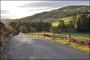 The trough road |
|
 Avenue of trees towards Langden. |
I was heading along the trough road and had a few easy miles to walk. At the Staple Oak buildings I was pleased to find another of the old re-used cast iron retorts now used as a gate post. It would originally have been used to generate gas from coal or charcoal from wood. It was a very nice morning and the sun was shining across the fells but hadn’t got high enough to reach me in the valley. |
|
|
After Sykes Farm I left the road and headed through a gate to the right and a farm track up the fell to the ruin of Trough House. It seems that the farm may have been demolished some time ago but the yard area was reasonably covered with concrete and even a PCWW (Preston Corporation Water Works) water stop tap box set in the concrete. The track continues up until reaching a large enclosure where the vehicle track turns to the left by the wall and the path heads off across wet open ground. Through a gate the path winds through peat hags and is soon on the top of Whin Fell. |
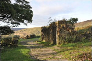 Trough House |
|
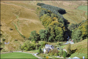
 Brennand Farm and valley from Ouster Rake |
After a short flat section the edge of the fell is reached and a wonderful view of the Brennand Valley opens up. The steep descent is by a path with the wonderful name of Ouster Rake. Before descending I sat for a while and sipped a cup if coffee while enjoying the views. At the bottom of the Rake I crossed a gently sloping pasture down to the yard at Brennand Farm. There was nobody about so I continued along the track north and over the bridge to cross the Brennand River. |
|
|
I decided to check out the stones first and was pleasantly surprised to see that they were of various interesting shapes. There was also some good shelter behind the largest outcrop so I stopped to eat my sandwiches. From the stones to the GB centre it is 225m so I crossed the fence and headed off across very rough moor. I’d assumed there’s be nothing to mark the spot so I picked up a flat rock to mark it when I got there. I soon reached it and found what appeared to be a hole in the ground which could have been made by a pole, though there was none to be seen anywhere nearby. I continued west to Brown Syke then followed Round Hill Water down to an interesting wooden footbridge. It was of suspension construction and seemed overdesigned for such a remote location. |
 Brennand Farm. |
|
 Whitendale |
Another farm track continued up to an area that looked like old workings and a large spoil heap. I was now on an indistinct path which I followed up to the wall and across to an old reservoir and dam. I’d now wandered off the path and had to navigate my way back to the correct descent route to Whitendale buildings. Across the valley I noticed a stone aqueduct which looked like one on the old photos I was searching out last week. |
|
|
When I’d reached it it turned out to be similar but not the one I thought it was. Over Calf Clough I re joined the path which followed and old zig zag track up on to the fell towards Dunsop Head. A stretch of wooden boards had been fixed to cross a rushy area so I used it for somewhere to sit and eat my lunch. I continued to the pass summit which I’ve never been to before and found an interesting junction of routes. To the east was down to Slaidburn but I wanted to head over Beatrix Fell and found the path along the wall to the SW rather indistinct. The first problem was a very wet area before Wisket Hill but once across it the going improved considerably. As I approached the trig point on Burn Fell I had good views ahead of Totridge summit and looking behind to Pen-y-Ghent. |
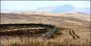 Pen-y-Ghent in the distance. |
|
|
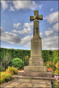
Heading to Beatrix Fell I
came to a strange area of stony and sterilised ground by the wall.
Broken glass was strewn about and at first I thought it was rubbish that
had been dumped but then I saw blobs of molten metal that had the look
of aluminium. It looked like the site of a crashed aircraft. A wooden
cross nearby confirmed this.
|
||
|
|
|
|
|
|
Continuing on to a bend in the wall I turned left and down to a gate access and a track sloping down off the fell. The views down the Hodder Valley were very impressive and it was so clear I could see the Welsh hills in the distance. At Beatrix Farm I crossed a large field to the River Dunsop where I crossed by a wooden footbridge. The tarmac road on the far side soon took me back to Dunsop Bridge and a lot more people than when I left. |
|