|
Whitendale, White Crag, Centre
of UK, Brennand, River Dunsop, Bowland.
[ 18.5 km]
Fri 25 Sep 2009 |
|
|
|
SD 6549 5152
My walk today is in the Dunsop Bridge area and as it’s less than an
hour’s drive I was able to start walking earlier than normal. From
Dunsop Bridge the road to Whitendale and Brennand is private and plenty
of signs remind you of that. As I was leaving some proof photos at
Bishop’s House for Paul I parked outside his house. As I was setting off
the Gamekeeper stopped to ask if I had a permit. I explained my reason
for being there and he seemed happy. I hadn’t been walking up the road
long when his assistant drove by and asked the same question. I
continued north along the estate road with the river Dunsop on my right.
Where the road splits so does the river. To the left the river Brennand
comes down the valley and to the right the Whitendale River. I turned
right to the main Whitendale buildings. The main building has a stone
shield over the door bearing the date 1854. The whole area was developed
as a water catchment for Blackburn Corporation Waterworks prior to 1884
so I don’t know if the building was part of their ownership. It not it
seems a large building to be in the middle of nowhere. I continued up
the valley along a farm track and then a way marked path to Salter Fell.
On the side of Whitendale Fell the indistinct path follows through wet
reed beds and the occasional wooden bridge to get over the worst bits.
Part of the way I was following the tracks of a tracked vehicle which
had crossed the Whitendale River at Higher Stony Clough. |
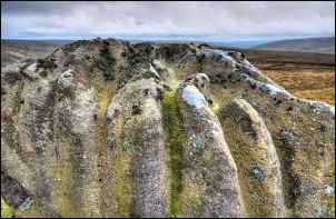
Whitendale Hanging Stones |
I had been here a couple
of weeks ago and seen the machine high on the fell below Burn Fell. It’d
assumed it was cutting a path up the hill so after crossing the river I
followed the tracks straight up the hill. The reason soon became
apparent. I came to a recently constructed shooting butt and higher up
were a line of others which had been there some time. When the gradient
eased and flattened I was on very rough and difficult ground with no
sign of a path whatsoever. I was now looking for the centre of Great
Britain which according to the Ordnance Survey is a point not too far
away. I’d put the co-ordinates SD 64188 56541 into my GPS and was using
that to decide the best way to go. I headed for the fence line coming
down from White Crag and following it made for slightly easier going. In
the distance were Whitendale Hanging Stones on the left of the fence and
the GB centre somewhere to the right of the fence. |
|
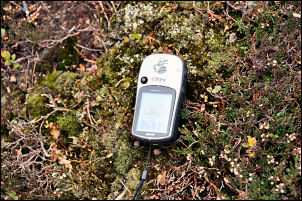
The Centre, the GPS reads SD 64188 56541 |
The Centre of Britain. |
|
Some notes on the centre
point from the BBC website.
According to the Ordnance Survey's definition, the centre of Great
Britain (factoring in its 401 associated islands) lies on Brennand Farm,
about seven kilometres north-west of Dunsop Bridge. On the exact point -
grid reference SD 64188.3 56541.43 - there is no monument or sign. It is
just an undistinguished clump of grass surrounded by peat bog. Ordnance
Survey spokesman Trevor Mouncey said the gravitational method was the
standard arithmetic principle of determining the centre of an irregular
two-dimensional object. As such it has been used by everyone from
Captain Cook to Nasa. It's a standard scientific application. Mr Mouncey
said the Ordnance Survey calculated the point at the request of a
customer, but he did not understand why it generated such interest. As a
cartographer, the centre of a land mass holds no romance or ethereal
connotations as every cartographer and surveyor knows there is no such
absolute, he said. I guess the less objective among us derive interest
and intrigue from these points and I guess it might have something to do
with the roll-out of scientific discovery over the last three centuries.
The location of Great Britain's true centre may never be entirely clear
because of arguments over what method should be used to calculate it and
the fact that Great Britain's shape changes with tides and erosion. The
basic problem is one of determining the centre of an irregular
three-dimensional object on the surface of a sphere, Mr Mouncey said.
Not only that, but the irregular object is surrounded by water which
keeps moving about and is also responsible for changing the shape of the
object on a daily basis.
|
|
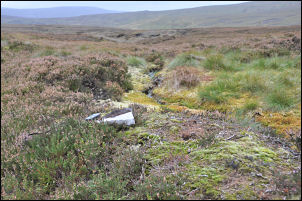
I decided to check out
the stones first and was pleasantly surprised to see that they were of
various interesting shapes. There was also some good shelter behind the
largest outcrop so I stopped to eat my sandwiches. From the stones to
the GB centre it is 225m so I crossed the fence and headed off across
very rough moor. I’d assumed there’s be nothing to mark the spot so I
picked up a flat rock to mark it when I got there. I soon reached it and
found what appeared to be a hole in the ground which could have been
made by a pole, though there was none to be seen anywhere nearby. I
continued west to Brown Syke then followed Round Hill Water down to an
interesting wooden footbridge. It was of suspension construction and
seemed overdesigned for such a remote location. |
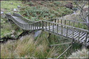
Footbridge on Brennand Fell |

Shooting Box on Brennand Fell |
A little south I came to
the wooden shooting cabin and the vehicle estate road. I followed it
down Brown Bank to the point where the old water aqueduct follows the
contour round the hillside. I followed the silted up watercourse via
Folds Clough and Well Springs Clough and also photographed the old stone
intakes dating back to the 1880s. At Far Pasture Clough I took the
direct descent down to Brennand Farm and left an envelope of paper
prints of the old photos for the farmer. There was nobody at home so I
left the envelope by the front door. I kept to the estate road all the
way back to my car and didn’t see anybody all the way back. Apart from
the gamekeeper and his assistant first thing I hadn’t seen anyone all
day. |
|
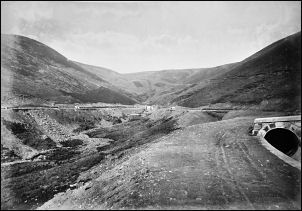
Folds Clough 1884 |
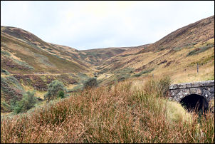
Folds Clough Sep 2009. |
|

Springs Clough 1884 |
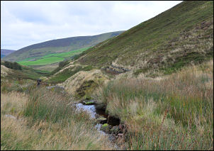
Springs Clough Sep 2009. |