|
Mungrisdale, Bowscale Fell,
Blackhazel Beck, Souther Fell, Cumbria |
|
|
Start/finish NY 364 305. |
 Blackhazel Beck and rainbow |
|
|
There were still deep fern in places but I was soon up. Above Raven Crags I joined the path which was quite nice and there was a wide grassy way through the ferns higher up. As I got higher on the ridge the wind and rain increased and I couldn’t see anything due to the cloud. The stone shelter on the top of Bowscale Fell was fairly miserable and I pressed on to descend south towards Bannerdale Crags. I wanted to head down Blackhazel Beck, a valley I’d never visited before. Although the map shows a path there isn’t one and I was soon wading across a area of unbelievable wet ponds, bog and squelch. I’d overshot my descent route and had to turn back on myself to find the beck. As I got lower I dipped below the cloud and had brief glimpses of the main valley ahead. |
|
The beck was in quite a
deep ravine and it was a bit tricky getting down the steep side. I came
to a sheepfold which was a good spot to shelter and have some lunch. I
then found the best route I could up to Mungrisdale Common, over the
pass and pick up the path below the base of Sharp Edge. I followed it
round and over the summit of Souther Fell. The NE ridge was a steep and
muddy descent towards Mungrisdale and some very tall wet ferns at the
bottom made it difficult for a while. I was glad to reach the road and
some easy walking for a change. After reaching the car and changing into
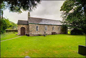
some dry clothes I had a quick look inside St Kentigern Church. There
has been a church here since about 550AD but the present building dates
from 1756. Some items are from previous buildings and the bell dates
from 1491. |
 Souther Fell cairn. |
|
|
|