|
Langdale, Oxendale, Great Knott,
Cold Pike, Pike of Bliscoe, Bleaberry Knott, Blea Tarn, Cumbria. |
|
|
Start/finish NY 2851 0530 |
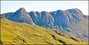
 The view from Oxendale |
|
|
The base of the Gill looks far too steep but it looked as though there could be a way higher up the ridge. The first part of the ridge was fairly straightforward but after crossing some nice flat shelves I came to a rather imposing face of rock and moss. It was just possible to find a way through it and detour round the several sheer rock faces. There was some relief as the gradient eased but another band of similar sheer rock appeared in front. It was the NE face of Gladstone Knott and was a little more difficult to get through than the last one. |
|
At last I reached the top of my last pitch and a nice flat grassy shelf appeared before me. Up ahead was Great Cove below the Crinkle Crags. I wandered across to the source of one of the rivulets than eventually form Crinkle Gill and found to my delight that it was a crystal clear spring issuing from the ground. I followed a dry gill up to the top of Gladstone Knotts where there was a very impressive view down the Langdales. It was also the ideal spot to stop for lunch. |
 Towards the Langdale Pikes |
|
|
I wandered down to the tarn on Great Knott and took a few photos before heading across open ground to Cold Pike. The main trail from Red Tarn to the Crinkle Crags was getting rather busy but there was nobody about on Cold Pike. I descended to the south side of Red Tarn and joined the main path up to the summit of Pike of Bliscoe. I left the descent path after a while and headed across open ground towards Bleaberry Knott. |
|
My objective was Blea Tarn but I couldn’t remember if there was a descent path down to it. As there’s no path over the Knott I doubted there would be. I was right. The Tarn came in to view and the nice weather had certainly brought the crows out. People were even swimming in the tarn. Some of the descent was a bit loose and lower down the rapidly growing bracken slowed me down but once on the path all was well.. |
 Summit of Pike of Bliscoe. |
|
|
I didn’t take the path
directly to the road due to the crowds but kept on it to the west of the
tarn were I joined the road at the summit. It was a pleasant descent and
the snaking road gives a nice foreground to the impressive view up the
full length of Mickleden. All too soon I was back at the car. |
|
|
|


