|
Ribchester, Ribble Way, Great
Mitton, Clitheroe, Lancs. |
|
|
Start OS grid ref:SD 6498
3531 |
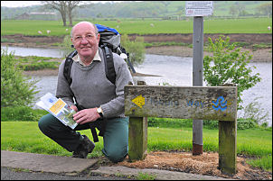 Eric at the start of the walk. |
|
|
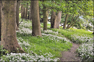
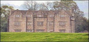
The path followed the river bank for a short way before joining a lane then the main B6245 Blackburn Road. Being a busy time of day it wasn’t very pleasant walking along the narrow path along the road. We were relieved to reach Ribchester Bridge and stopped briefly to look over the parapet to the boarded up De Tabley Arms. Many years ago it was a magnet for days out, especially at the weekends. The whole area would be full of cars and people would sit on the grassy banks of the River Ribble like Blackpool sands on a sunny day. But not any more as I’ve hardly seen anyone here for years. We followed the farm track to Dewhurst House before noticing a sign to point us right and back to the river bank. We were now in open fields and had nice views all around. The impressive Salesbury Hall soon appeared across the river. There was a very strong smell of wild garlic as we passed through Haugh Wood. |
|
We left the river bank and headed up a climb to the left and across fields to Hey Hurst where we crossed the track then back into the field and down to a footbridge. We were approaching the river again and could see the Dinkley footbridge in the distance. The Ribble Way doesn’t reach the river but passes by Trough House and up the lane to a concessionary path to the right. It took us along the top edge of a wooded area above Raid Deep then dropped steeply down to a path along the river side. A stone aqueduct carrying 2 large dia. water pipes appeared to our right. A sign said Fylde Water Board so it must carry water supplies to the Blackburn area as the Fylde were responsible for Blackburn many years ago. |
 Fylde Water Board Aqueduct. |
|
|
The path was nice and flat and had wide views all around. At a group of building called ‘Jumbles’ we could see where the shallows of Jumbles Rocks appears in the river. This is a point where it was supposed to be possible to ford the river in centuries past. The next building we came to was Hacking Boat House which looked like a weekend cottage. The route of the path shown on the map was not visible on the ground so we crossed a meadow to reach a track by the river. On the far bank we could see the River Calder join the Ribble and also the impressive early Jacobean (1607) Hacking Hall. On the approach to Winkley Hall farm the river has another junction. Across to the right is the River Ribble and we continued along the River Hodder. This is where we leave the Ribble for a few miles. |
|
|
|
|
|
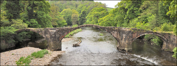
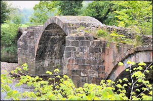 The Old Hodder Bridge. |
|
We walked through Winkley Hall Farm and stopped to peer into the pond where large goldfish swam slowly. The farmer was in the yard and we had a chat about the pond and its origins. The Ribble Way guide book suggests it is part of an earlier moat around the farm but the farmer said it was just an old mill pond that fed a water wheel on the other side of the farm. A short climb took us to Winkley Hall which was an impressive red brick and tiled house. We crossed fields above Spring Wood and came to the main B6243 which we’d travelled along earlier on the bus. A short descent took us to Lower Hodder Bridge and the old Hodder Bridge which is also called Cromwell’s Bridge. This was a perfect spot for our lunch stop so we sat on the top of the bridge in weak sunshine to eat our sandwiches and muse over the history of the bridge, built in 1562, and the people who would have used it. |
|
|
Returning to the road we walked to the Three Fishes at Great Mitton. It didn’t look open from the front but there were lots of cars parked round the back so presumably it’s a restaurant. We returned to the Ribble at Mitton Bridge then thankfully left the road at the Aspinall Arms to head off across fields towards Shuttleworth Farm. Just before we reached it there was another water pipe aqueduct crossing the river. It carried 4 large diameter pipes and I can only assume this is the Haweswater Aqueduct which carries water from Hawewater in Cumbria to Manchester. We followed Henthorn Rd and left it to approach Siddows Hall. A recent footpath diversion had made the guide book out of date in this area. Talking to a local it appeared the owners of Siddows Hall didn’t want a footpath through their field so it was diverted round the outside. We dropped back to the river bank and soon came to a recreation area called Edisford Bridge. There was an out of use miniature railway line there. At the bridge we left the river and followed Edisford Road for a while before leaving it at the sports centre, crossing the running track to Low Moor then along a track to a large weir just before Brungerley Bridge. Crossing over the road we came to the sculpture trail which has various things carved in trees and also the occasional carving in stone. Once out of the wooded area we were back on an open path following a much smaller River Ribble. At Bradford Bridge we’d reached the end of the days walk but drove on to Sawley to check out that area for when Eric does it in Aug. |
 Tree carving near Brungerley Bridge. |