|
Ribblehead, Old Ing, Ribble Way,
Gearstones, Gayle Moor (source of River Ribble), Yorkshire. |
|
|
Start/finish OS grid
ref:SD 7852 8030 |
 Ribble Way waymarker |
|
|
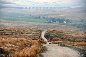
After passing Old Ing buildings I left the track and followed the path off to the right which is nothing more than an area of flattened grass. I was now on the official Ribble Way route and I was soon on another track heading for God’s Bridge. I was puzzled by the name as there isn’t actually a bridge. The river vanishes underground and emerges naturally on the other side of the track. The was a very nice wooden footbridge over Ling Gill Beck just before reaching nether Lodge. The path now splits into 3 and the continuing Ribble Way route is far from obvious. It takes a NW line across open ground and the only indication that you’re on it are the muddy footprints of those that have gone before. |
|
Eventually Back Hools Barn came in to view and I stopped there for a while to have a look inside. It is in an advanced state of decay but the original cattle stalls are still inside with wooden frames and slate infill. Over the hill is Nan Bottom Lane where I turned right and followed the track and path to Thorn Gill. I had to walk a little downstream to find the footbridge which I crossed and walked the short way up the main B6255 road at Gearstones. I turned right and followed the road for a few minutes to Far Gearstones and then turned left to follow an access track to Winshaw. This where the Ribble Way leaves the river for quite way and I’m surprised that it follows this route when the road runs right along the river bank. The river is actually Gayle Beck as the name ‘River Ribble’ ceased a while back. |
|
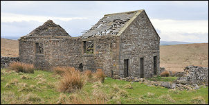 Back Hools Barn |
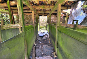 Back Hools Barn interior. |
|
|
Above the buildings the path follows above a wall until High Gayle is reached and the wall turns to the right. Here is where a fenced off area appeared ahead. It looked out of place and as I approached saw that it was a grave. [following text removed after objection] |
|
My original write up had reference to a grave at this location. For some unknown reason a relative of the deceased objected on 4 Jun 2010 so I have removed the reference. This website is nothing more than an on-line version of my personal diary. The location is on a public footpath and I can not be officially required to remove the reference. However, I have removed it so as not to upset relatives. [check090414b_for_orig] |
|
| picture removed following objection |
Picture removed following objection |
|
I crossed over and followed a track heading up onto the moor. It is in good condition and easy to walk on. Above Jam Syke a wall is reached called Gavel Gap and the map seems to indicate this is the end of the Ribble Way but it is possible to follow Jam Syke a little higher until it reaches a limestone outcrop and a trickle of water issuing from its base. Just above is the watershed. This side all the water drains into the Ribble and the other down in to the River Ure down Wensleydale. My GPS gave the source altitude as 566m (1,857ft). I continued upwards to a wall above Cam Cob and followed it south along Gayle Moor End. It was easy pleasant walking, dry underfoot and nice views. I crossed the wall at Cam West End and joined the Cam High Road at the cairn where the Dales Way joins it from Oughtershaw. For the next mile the track is both the Dales Way and Penning Way but at Cam End junction the Pennine Way runs south while I descended west back to Gayle Beck and my car along the Dales Way. |
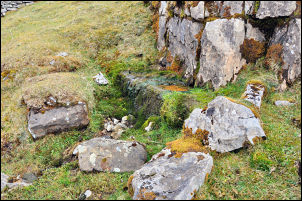 Source of the River Ribble The dribble that starts the Ribble. |