|
River Lune, Thwaite, Castley,
Long Rigg ridge, Fell Head, Whin's End, Brunt Syke, Cumbria. |
|
|
The mornings are now getting much lighter. It was light when I left Crook of Lund Bridge just before 8am to set off along the path which follows the east bank of the River Lune. It was overcast and fairly gloomy as I walked through the trees but it was nice to see a small deer on the far bank and several oystercatchers flying upstream. |
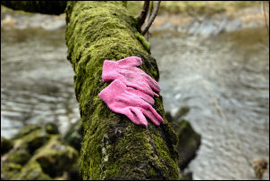 Lost gloves by the River Lune. |
|
|
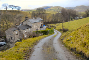
The walking was easy and pleasant but at Thwaite farm I left the flat riverbank and headed steeply up to the stile that leads into the farmyard. I spoke to the farmer’s wife and mentioned the conversation I’d had with there husband a couple of weeks ago. |
|
Continuing up the access road I turned left down Ing Lane to Chapel Beck and the church. I joined the main Howgill Lane and turned left as far as Gate Side where I took a high stile over the wall and across the fields to Castley Farm. The views across to the hills were very good. I followed the track which skirts the south side of Castley Knotts and followed it to the ford at Long Rigg beck. The main track runs up White Fell but I wanted to investigate the Long Rigg Fold area which I accessed by following a good track up Long Rigg Beck. |
|
|
|
I checked out the sheepfold before heading up Long Rigg ridge to join a faint quad bike track. The track soon petered out but the going was good underfoot and I enjoyed the steady walk up as the views opened up all around. There were a few flat areas which would make good tent pitches but the only water around was in Long Rigg Gill down to the west. There was a substantial drop down in to Crooked Ashmere Gills so I climbed until the gradient eased a bit before stopping to eat my sandwiches. Over the summit I took the direct path down to Whin’s End. I headed towards Howgill Lane but there is no path marked on the map. When Whin’s farm came in to view I still couldn’t see any path to follow so headed towards Farmile Beck instead which I followed all the way down to the bridge at Fairmile Gate. |
|
I crossed the road and continued down the riverside following a faint path. Nearing Low Wilkinson’s I had to climb an easy fence to join the main public footpath which I followed south past Mire Head to Brunt Sike. Brunt Sike was empty but had been substantially rebuilt recently. It looked more like a second home or holiday home. The continuing path is not well marked and I had to refer to the map a couple of times to find Nether Fields Wood and the path down to the river and back to Crook of Lune bridge. |
 Crook of Lune Bridge |