|
Tebay, Roman Road, Beck House,
Whins End, Blakethwaite Bottom, Archer Hill, Cumbria. |
|
|
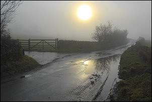
I didn’t have as far to drive as usual so I arrived in Tebay about 7:15am and it was still dark. I took my time getting ready so there would be a bit more sight when I set off. The lack of light wasn’t too much of a problem as the first part of my walk was south along the A685. Even with the M6 motorway close by there was still a fair amount of traffic on the road. The bus stop was also busy with children waiting to go to school. At Lune’s Bridge I left the road and walked along the subsurface track towards the buildings at Brockholes. It was still quite misty in the valley bottom and the views across the river Lune and towards the M6 motorway were hazy. |
 The school bus arriving in Tebay. |
|
|
However, it looked like the mountain tops could be clearer so I looked forward to the time when I could gain some altitude. There was a nice wide filed to cross before entering a wood and narrow path by the riverbank. It emerged at Salterwath Bridge where several vehicles were parked. They were for some workers who were working below the railway embankment across the river. I followed the road to Carligill bridge and had a brief look at the boundary stone just below Gibbet Hill. As I walked along the unfenced lane all the sheep from the fellside came running down to the road. Hey flocked around me an must have assumed I was the farmer coming to feed them. They followed me for quite a while. I left the road to turn left up the track to Beck House Farm. The path was signposted between some farm buildings and along a muddy track. Through a gate I finished up in a field with no indication where to go. |
|
It was quite boggy so I kept high above Ellergill Beck, passed an old ruin and came to a dead end. There was nothing for it but to climb the wall and fence and I managed it without doing any damage to the wall or me. I eventually rejoined the correct path at Beck Houses Gate. Continuing up I joined a delightful path below brown Moor and heading towards Whin’s End. It followed a steady gradient and was well constructed and must be an old drove road. By now I’d left the mist behind and had good views. In Whin’s End there was a nice spot to sit in the sun and enjoy the view while eating my sasndwiches. |
|
|
|
The track continued to Blind Gill and up to the saddle between Blake Ridge and Linghaw. I crossed over and the track narrowed but was still easy to follow and gave superb views down into the deep Carlin Gill. I continued following the contour until the final descent to the Blakethwaite Stone where I noticed what looked like an old Ordnance Survey bench mark which I hadn’t notice before. I climbed up to Uldale Head and still had great views. |
|
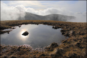
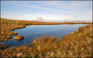
My next objective was to investigate a small tarn on Archer Hill which I hadn’t visited before. There is an easy path to Rispa Pike but I had to leave it to cross open ground to Archer Hill. Just over the hill the tarn came in to view. It looked very picturesque under the blue sky and the views down into Lantley Gill were good as well. Below Whitefold Moss the indistinct path joins a stoned track which I followed north to Weather Hill. The map shows a path across to Waskew Head farm but there is no sign of it on the ground. I had to guess the route across as the buildings don’t come into view for a while. Several old vehicles were scattered around and the buildings looked run down but occupied; though nobody was about. I continued down the access track, which was quite rough in places, until I came to some lock up garages and Tebay. |
|