|
Martindale, Sandwick, High Dodd,
Place Fell, Boredale Hause, Beda Fell, Cumbria. |
|
|
I arrived at St Martin’s Church, Martindale under a clear sky but as the sun was still low there was no sun reaching the valley bottom. I walked back along the lane to Howegrain Lodge and telephone box. The building was in a reasonable state of repair but didn’t seem to be being used for anything. Above the door was a date stone A.D. 1913 and a stone to the right of the door saying Mrs HASELL OF DALEMAIN LAID THIS STONE ON JUNE 26th 1913. To the left of the door another stone says RESTORED BY HER GRANDDAUGHTER Mrs McCOSH OF DALEMAIN 1982. I followed the lane to Sandwick and took the track which heads off towards the banks of Ullswater. Before reaching Scalehow Force I headed up to the left to take the path by Scalehow Beck. |
 Ullswater from High Knott |
|
|
The views across Ullswater were excellent but I was still in shade. It’s the first time I’ve been on this path and I was surprised at the size of the ruined building by the old quarry just below High Dodd. The size of the quarry didn’t seem to justify it. I reached the sunshine at the sheepfold on Low Moss and took the opportunity to stop for a coffee. The sun wasn’t as warming as I’d hoped so I didn’t hang around. I took the path to the west of Hart Crag and sat for a while by Mortar Crag to take in the views. There was a clear view directly into Glencoyne where a couple of weeks ago I’d been forced to stay in my tent due to severe winds. There was hardly any wind today and I continued up the path, very wet in places, up to the summit of Place Fell. |
|
The Ordnance Survey trig point column is perched precariously on a pinnacle of rock and care is needed if going up to it, especially if it is windy. I continued to Round How and started the steep descent to Boredale Hause. On the way down there were many people walking up, presumably taking advantage of the sunny weather. |
 Place Fell trig point. |
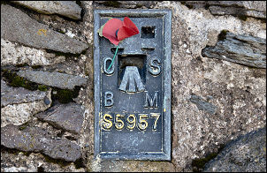 Trig point plate on Plate Fell |
I passed the ruins of Chapel-in-the-Hause and took the minor path to Freeze Beck. It isn’t obvious which the correct path is and it isn’t confirmed until the beck is reached and the view opens towards Beda Fell. |
|
At Beda Fell Knott it isn’t obvious where the highest part of the continuing ridge is. The highest point is reached at Beda Head at 513m. The low winter sun gave very nice light on the valley bottom and as I descended I had good views down to St Martin’s church. By the time I got back to the car there were many more cars parked around. |
 Patterns in Martindale. |
