|
Haweswater, Old Corpse Road,
Selside Pike, Branstree, Harter Fell Nan Bield Pass, Cumbria. |
|
|
An overcast day was forecast and as I drove along the Haweswater road to the car park I saw the Met. people were right. The autumn colours were there but no sunlight to bring them out. There was no wind forecast and only light wind. I was the only one on the car park and even walking back along the road to the start of the old Corpse Road there was still no one about. |
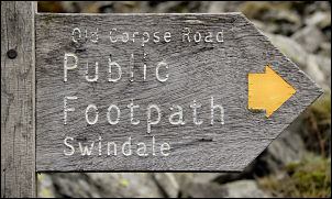 Start of the Old Corpse Road. |
|
|
I left the road and set off up the Corpse Road, which is actually just a path but well engineered and easy to climb. Higher up there is a ruined stone building which I’d camped near many years ago. Looking across to Selside I couldn’t see it, just the way up vanishing into cloud at around the 500m contour. The path runs to the left of Rowantreethwaite Beck and the gradient soon starts to ease. I still couldn’t see anything of the fell tops so took a line directly across towards Selside End to start my ascent. It was wet at first but on High Blake Dodd it became firm underfoot and thick cloud. |
|
I kept climbing through the gloom until the cairn and wind break on the summit of Selside came in to view. I followed the fence to the SW until I guessed I was adjacent to the un-names summit to the left. One of my objectives was to find a stone pillar that is shown on ‘Google Earth’ and is somewhere on this fell. I had noted the exact position and entered it into my GPS unit. The thick mist was certainly a hindrance and I only had a few metres visibility. With nothing to see I followed the GPS until I arrived at the coordinates. There was nothing to see so I wandered round in a circle for a while before heading off in the direction of Branstree. |
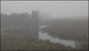 Branstree in the cloud. |
 Harter Fell in the cloud. |
I followed the fence to the summit and once there stopped behind the wall to shelter from the wind and eat my lunch. On the descent to Gatescarth Pass I noticed a couple of ‘L’ inscribed boundary stones. At the path I crossed over to start the climb to Harter Fell. I heard voices in the mist ahead and a couple of women walkers descend asking the way to Branstree. They’d been heading in the wrong direction so I put them right and continued up. There were no views and when I go to the top a lone walker was there in the mist. |
|
I didn’t stop but headed west to make the steep descent to Nan Bield Pass. Descending to Small Water I eventually came out of the cloud and was able to get my first views. Some people were sat by the tarn as I passed. I took a few pictures of the interesting stone shelters and continued the easy descent back to the Haweswater car park. |
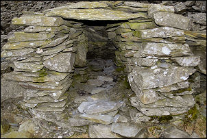 Old stone shelter by Small Water. |
