|
Longsleddale, Gatescarth Pass,
Branstree, Artle Crag, Mosedale Quarry, Cumbria. |
|
|
I set off with Steve a little later than normal. It was coming light under a mostly clear sky but passing Preston at 7:30am is not good as the motorway was very busy. When we drove through Kendal the traffic was fairly light. The road soon cleared completely as we headed north along the A6 until just short of Watchgate where we turned left down the narrow lane to Longsleddale. The cloud then rolled in and lowered and light snow began to coat the road so even more care was needed. We reached the end of the tarmac road at Sadgill and just after we parked another car turned up and a walker got out to head up Grey Crag. We continued north walking along the track towards Gatescarth Pass. |
 Longleddale. |
|
|
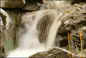
Light snow continued as we climbed into cloud. The river on our left was quite attractive in the snow. They didn’t show a name for it but lowerer down it is called the River Sprint. We reached the gate at Brownhow Bottom and crossed the river by stepping stones and headed across to the area of old quarries and spoil heaps. The path was fairly distinct and we followed it up to the fence and gate below Selside Brow. The cloud had lifted a bit but some sections of path were very boggy but passable with care by hopping across outcrops of rushes. We then followed the fence north up the hillside towards Branstree. |
|
The going was quite good underfoot and we took it steadily, following the fence which became a stone wall when we got higher. There was chill wind coming in from the left but with wind proofs on it was comfortable walking. We reached the summit stile and crossed the short distance to the trig point which is one of the few ground level circular types. There was a great view along Haweswater as the cloud had lifter just enough to reveal the fells. We visited a couple of nice cairns on Artle Crag which is a small area of rock outcrop amongst the grassy fells. Crossing the wire fecen our next call was the magnificent stone survey pillar which was used during the construction of the Haweswater reservoir and outlet aqueduct tunnel. |
 Steve by the survey pillar. |
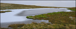 Frozen tarn near the survey pillar. |
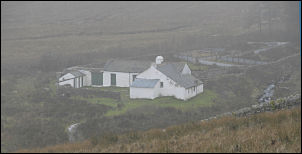
Just to the east was the frozen unnamed tarn which we’d also come up to check out. Our next objective was the huge quarry above Mosedale Cottage which we’d seen two weeks previously from below. The cloud had rolled in again and we didn’t have much of a view |
|
We continued along the contour until we were above the quarry and then took a direct line down the fell. The visibility was bad and we’d reached the edge of the quarry and still couldn’t see it all below. We were amazed how big it was as there is no view from the surrounding fells that give a full appreciation of the quarry. Stone had been quarried here from about 1880 until the early 20th century. |
 Misty Mosedale Quarry. |
|
|
Fortunately there was a gap in the wall on the descent so we easily joined the track to Mosedale Cottage where were we once again stopped for the perfect lunch spot. It was interesting reading the log book entries since we were last here 5 pages ago. It is very sad to see that some people think putting profanities in the book is clever. We left the cottage exactly as we’d found it and started to climb the boggy path to the SE. We were heading back to Gatescarth Pass and the boggy path back to the fence gate took quite a few detours to prevent a soaking. At the gate we were on familiar territory and made the descent back to the Gatescarth Pass track. The snow had stopped and the weather had improved a little as we descended the stony track back to Sadgill. |