|
Wet Sleddale, Swindale, Mosedale
Cottage, Sleddale Hall, Cumbria. |
|
|
I set off with son Steve in the dark and as we drove along the M6 motorway torrential rain hit us north of Lancaster. Fortunately it had stopped when we reached Shap but the fells would be waterlogged after heavy rain over the last 36 hours. As we approached the car park at Wet Sleddale Reservoir the overflow weir was gushing water. We set off and the sky began to clear. It was chilly at 7degC but soon became comfortable to walk in. Just after Cooper’s Green was a fenced off area to the right. It had various instruments dotted around and had a Met Office sign on it. Presumably it is the weather station which records the information shown on the Met Office website. We continued along the road until the branch north along the waterworks road. It’s not an adopted road and there is a sign saying road ahead closed, but everybody uses it. For the next mile and a half we had an easy walk and were able to gaze at the surrounding scenery without keeping an eye underfoot. |
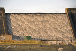 Overflow at Wet Sleddale Reservoir. |
|
|
A couple of lady joggers approached from the Keld direction but they seemed to be doing more walking than jogging. We took the left turn to Tailbert Head and followed the dead end road to the farm entrance. This was to be the end of dry feet. The path was clearly visible across Dog Hill but considerable lengths were swimming in water and some ankle deep bog. On the brow of the hill things dried a bit but the damage was done. |
|
On the plus side we got a very nice view down into a sunny Swindale before starting the descent. The sky remained mostly clear and we didn’t have any more problems until the valley bottom where we had to negotiate some more very boggy ground to reach the footbridge over Swindale Beck. We were back on tarmac for the next mile until we reached Swindale Head. A sign points up to the right indicating the Old Corpse Road over to Haweswater and what was Mardale. The path we’d come along must also have been part of the same route from Mardale to Shap. We continued straight on to follow the stony track between walls towards the climb up to Mosedale. Approaching the river there was a natural causeway to carry the track. The interesting thing to note is that the boggy area of Dale Bottom seemed lower than the river level. After a brief coffee stop we set off up the zig zag path which seems to have been engineered as it is cut into the hillside and follows steady gradients. Higher up the ground was very wet again but improved for a while when we got to the valley bottom of Mosedale Beck. |
 View of Swindale. |
 Mosedale Cottage. |
The easier going didn’t last for long and the track was rutted, full of water and mostly had to be negotiated by making constant detours on the uphill side. We reached the bridge at the point where Little Mosedale Beck joins the main river. We continued upstream to the point where an old bridge is shown on the map but all there is now are the two abutments. We kept to the riverbank for a while then cut across to the right to rejoin the main track. Soon we could see Mosdale Cottage in the distance. |
|
It seemed to have been recently painted white and looked too good to be in such a remote location. We reached the ford at the river and fortunately the level wasn’t too high so were able to cross the stepping stones without getting our feet even wetter. The cottage is maintained by the MBA The Mountain Bothies Association and was in its usual pristine condition. The only omissions were the comfy chairs which used to be there and now there are only basic chairs. It was the perfect place for our lunch stop and we munched our sandwiches and read the log books. |
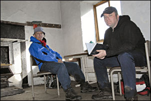 Me and Steve in Mosedale Cottage. |
|
|
After making a short entry we retraced out steps along the wet track back to the bridge. Crossing over we climbed steadily up to Scam Matthew. |
|
The weather continued fine and the view down into Wet Sleddale soon opened up. We had a mile to walk before we could see our next objective, Sleddale Hall. Its 2 years since I visited and Steve wanted to have a look at it as it was one of the filming locations for the iconic 1988 film ‘Withnail and I’. It was much as I’d left it except that other film fans had visited and written graffiti on the door. We followed the track down towards Mirethawite then over a stile to the left and down to the stone bridge over the River Lowther. This was the filming location for the scene from the film where Withnail (Richard E. Grant) went fishing with a shotgun. There was some very wet ground to cross before reaching the New Ing buildings. A good track then took us back to the car on the reservoir car park. |
 Descent to the reservoir; Sleddale Hall can jut be seen. |

