|
Hare Shaw, Selside Pike,
Mosedale, Swindale, Cumbria. |
|
|
After a clear drive to Swindale via Shap and Rosgill I was lucky enough to arrive at the start of the valley just as the sun was rising. I stopped to take a quick photo. Under Bewbarrow Crag is a large area of grass verge which was the ideal place to park. It turned out to be the only place as there was a ‘no parking’ sign for the rest of the road which is a cul-de-sac. I set off to follow the path sign heading up the hill. |
 Sunrise. |
|
|
It leads to a dead end on private land. By wading though deep ferns I managed to regain the correct route which climbs diagonally below Bewbarrow Crag. It took me up on to Rosgill Moor where I picked up the main track along the ridge of the hill towards Hare Shaw. The track generally follows the wall but kept vanishing into bog. It actually goes to Mardale Banks and that’s where I’d intended going but the horrible wet ground changed my mind for me. No paths are shown to Hare Shaw summit but it looked so appealing in the distance I decided to head for it. Apart from a couple of short detours the going was quite good. |
|
|
 An interesting concrete stile. |
 Riggindale from Hare Shaw. |
 View down Swindale |
|
|
The weather continued fine and the views were excellent. I then headed for the interesting looking Woof Crag. The short distance took a long time and lots of detours because of horrible boggy ground. The struggle was worth it and I sat for a while to enjoy a coffee break before descending to the Old Corpse Road near High Birkin Knott. Surprisingly the wooden marker post was still in place. I crossed the track and continued up towards Selside Pike. On High Black Dodd I came across a nice dry grassy track but didn’t follow it for too long as I wanted to have a look down into Dodd Bottom and across to Hobgrumble Gill. I found a nice sheltered spot out of the wind and as it was so nice I decided to stop for an early lunch. |
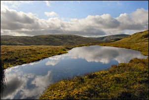 Tarn to Sleddale Fell (colour) |
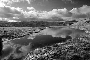 Tarn to Sleddale Fell (black & white) |
|
Back on the track I had an easy walk to the summit of Selside Pike and its large pile of stones forming a windbreak. I started to descend to the east by following the wire fence but it was such a nice day that I modified my planned route and turned south towards Howe. I’m glad I did because it’s an area I’ve not walked in before and found it was a delightful mix of humps, bumps, rocky outcrops and small tarns. Just before I started my descent to Mosedale Beck I came across a very picturesque small tarn which looked unnaturally blue under the equally blue sky. Peering into the water revealed a very dark peaty colour. Just before Mosedale Beck I came to the main path which soon became very wet as I approached the head of Swindale. Lower down it is well engineered but still wet. At the bridge I reached the rough walled track to Swindale Head buildings where the tarmac road starts. For the next couple of miles I had a pleasant walk back to the car and the only vehicle on the road was the postman’s |
|

