|
Garsdale, Galloway Gate, Great
Knoutberry Hill, Widdale Little Tarn, Yorkshire. |
|
|
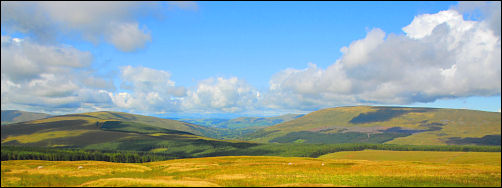
The weather report for today was good but not for the rest of the week so drove to Garsdale Railway Station, Yorkshire. Left the car near the station entrance and headed up the steep lane in the direction of Dent Station. The map calls it Galloway Gate. As the gradient started to ease a bit I noticed a large cairn up on the left horizon but I couldn’t find it on the map. It was a very pleasant walk along the lane as it climbs to over 500m and the views down Garsdale and then Dentdale are very good. The weather continued clear with lovely cloudscapes. About a mile before Dent Railway Station there is a left branch track off the road. I took it and followed the contour round. To my right were fantastic views down Dentdale. |
 Monkeybeck Grains and Whernside in the distance. |
|
|
|
|
|
I came to a gate and turned left up the fell to follow a fence line. There was a faint path to follow but as I got higher I noticed some nice tall cairns on Pikes Edge. I left the path to investigate the tallest. I was soon back on the path and climbing to the summit of Great Knoutberry Hill. The summit trig point was on a cairn of stone and nearby was a nice tall windbreak which was just right for the prevailing wind direction. I stopped here to eat my sandwiches while looking down Widdale and across to Wensleydale. My next objective was Widdale Great Tarn to the NE. There was no footpath but it wasn’t too bad underfoot. |
|
The tarn wasn’t very impressive but I continued on to Widdale Little Tarn which was much smaller but more interesting. In the middle was a shooting butt made of stone. To get there a stone causeway had been constructed. With no footpaths in the area it must be rarely visited. |
 Widdale Little Tarn and causeway. |
|
|
|
|
I wanted to have a look at Widdale Fell so set off to follow the stone wall in that direction. The going was extremely difficult and wet. By the time I’d reached Sandy Syke Head I realised I wasn’t going to make it from this direction and would have to try another day from a different direction. I turned NW and headed down by picking a tortuous route through boggy ground and tall peat hags. Below I could see a vehicle track which isn’t shown on the map. As I approached it I saw a Land Rover parked on the opposite side of the valley. At the track I sat on a large boulder to decide which way to return to Garsdale. The Land Rover soon appeared and the ranger driving it asked if I was lost. I told him I wasn’t. He headed off back and I followed in his direction. I continued along the track and saw him again. He told me it eventually joined the main Galloway Gate Road or Coal Road as he called it. It was nice to walk on firm ground for a change but I wasn’t too happy about the route it was taking. It seemed to be going in the wrong direction. I headed off across open ground on a compass bearing and eventually met the road again. I re-joined the road and descended back to Garsdale Station. I had a look round the small station and checked out some building work that was being done. Quite a few people were waiting for the train which was nice to see. |
|