|
Staveley, Potter Tarn, Brunt
Knott, Cumbria. |
|
|
The weather forecast was bad. Rain was forecast to sweep in from the south so I decided to stay on a low level walk. I reached Staveley quite early and then set off up towards Piked Howe to find somewhere to park. Over Barley Bridge I turned right and followed a narrow walled lane which soon began to climb quite steeply. I’d checked the map before setting off and noticed the road in the vicinity of Pike Howe was unfenced and so should have plenty of parking spaces. Unfortunately when I arrived the whole area had ‘no parking’ signs stuck in every piece of grass where a car could go. Obviously visitors are not welcome in this part of Cumbria. I continued along the lane to Littlewood Farm where there was plenty of space to park but I didn’t want to leave my car without checking. There are a few houses adjacent so I thought I’d find someone to ask. I wandered around but couldn’t find any sign of life. Perhaps 7:15am is too early for Cumbria folk! I continued on my way to the junction with Hall Lane where there was a wide enough verge to tuck my car up by the wall. I set off walking along the lane back the way I’d come. Passing Littlewood Farm houses there was still nobody about. |
 Near Littlewood Farm. |
|
|
I didn’t take the Birk Field turn off but continued on the road a while and left by a track which connected to another track to Frost Hole. The farm building is tucked away in a deep valley and can only be seen when almost there. The path goes through the farmyard which still has it’s ancient small stone cobbles. Unfortunately there was nobody about as I would have liked to talk to whoever lives there. |
|
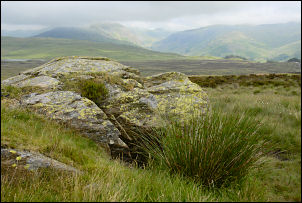
A cobbled track left the farm and then I was on the fell side. A marked path leads steeply up towards Potter Tarn. As the ground levelled off the tarn came in to view. Across at the far end can be seen a large concrete dam which indicates that it’s current inflated size is for industrial use. It looked like the water level had been much higher at some time in the past. I turned left and headed up the fell again. The map shows a track just to the north so I joined it but before long it petered out and I just found the best sheep tracks I could to avoid the heather and worst of the boggy ground. I managed to keep reasonably dry as I crossed to the footpath at Black Beck. I was now on much better ground and had easy walking as I climbed the SE side of Brunt Knott. The Ordnance Survey trig point is built of craggy stone and not the usual concrete pillar. |
 Trig point on Brunt Knott. |
|
|
The views were quite good but the low cloud kept things rather dull. Most of the distant hills were visible though. A faint track lead down to the NW and a gate in the wall. Judging by the two piles of stones it looked like the gate had only recently been fixed or enlarged. I turned right to head for Dockernook Gill then across wet rushes to join a path which heads north to Black Beck. Once over the brow of the hill I had nice views up Longsleddale towards Gatesgarth Pass in the distance. A faint track kept roughly parallel to the wall and was very pleasant walk with occasional boulder outcrops. I used one as an ideal lunch stop and ate my sandwiches while admiring the scenery. |
|
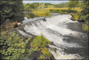
I continued down until I reached Black Beck and the path connecting Longsleddale at Wadshowe Bridge and Hall Lane. I turned left and followed the path to the wooden bridge over Skeggleswater Dike. A little further on it joins the main path coming down from Cocklaw Fell. At Staveley Head Fell it improves and is surfaced with stone. At Park House Farm I stopped to watch a Farrier at work in the yard. He was cutting a thread into a horseshoe with a tapping tool. I’d not seen that done before and he said it was for screwing studs in for competition work. |
 The Farrier at work at Park House. |
|
|
I continued along Hall Lane until returning to the car. |