|
Walden, Naughtberry Hill,
Buckden Pike, Yorkshire. |
|
|
I had a pleasant and sunny drive along the M6, through Sedbergh, Hawes and Aysgath. It was still early morning so none of the slow tourists were about yet. I was heading for the valley of Walden Beck a few miles south of West Burton. I was surprised how picturesque West Burton was as I passed through. It was my first visit. It was also my first visit to the valley and I had no idea what to expect. The access lane leads to the south. It soon splits to dead ends which lead up the west and east sides of the valley. I took the west and longer route as far as Bridge End Farm. I didn’t go any further because it is quite narrow and I didn’t think there’d be anywhere to park; I later found out I was right. I parked across from a telephone box and what looked like the old chapel. |
 The road at Walden. |
|
|
My first objective was Naughtberry Hill and with no footpaths shown on the map I had to find the best way up I could. Near the entrance to Hill Top Farm was a piece of wooden fence where I could easily climb over and find a way up the hillside parallel to some trees and a wall. Higher up the gradient eased and I came to a rough vehicle track which leads up on to the high moor. As I approached a gate a couple of farmers on quad bikes came up the track from the valley bottom to round up a few sheep that were about. I continued through the gate for a while then turned sharp back on my self up another track towards an area of old mine workings. The whole area was dense heather and more suited to grouse than walking. Judging by the number of grouse around and shooting butts it must be a grouse moor. As I got higher I noticed a tall narrow stone cairn which I investigated before heading off again in the direction of Naughtberry Hill. |
|
It was quite difficult underfoot so I headed for a higher area of more grassy ground. I came to the point on the map called Dewersit Well which was just a spring issuing from the hillside. I continued up until I came to a bit of fallen down wall then followed a wet and very rough faint path up the central ridge of the hill. A line is shown on the map, presumably a boundary, but there is nothing to see on the ground. Continuing SW over Naughtberry Hill there is nothing of note or interest so I plodded on until I came to a fence and gate. I continued along the same direction until the gradient steepened and I climbed the final stretch to the top of Buckden Pike. |
 Muddy path on Buckden Pike. |
|
|
I was on the left of the stone wall and the trig point was on the other side. I didn’t visit it but kept on until I could find some shelter from the wind to eat my lunch. The sky was mostly clear and apparently the south of England was having its hottest day of the year but it didn’t feel particularly warm here. By the wall was a boundary stone with RH 1810 cut into it. |
|
I followed the wall south then crossed over to the memorial cross which stands near a bend in the wall. It was built around 1972 to commemorate the crew of a Wellington bomber which crashed here on 30 Jan 1942. The bomber had a crew of 6 Polish airmen which took off from RAF Bramcote, Warwickshire on a training mission. The only survivor was Sergeant Joseph Fusniak. The concrete base of the cross has pieces of wreckage built into it and people who have found pieces of wreckage have placed them around the base. I continued along the wall and came to a gate and another path coming up from the valley. Nearby was an interesting marker stone with the marks B + O cut on one side and an Ordnance Survey bench mark on another. I continued south along the wall then started to cross an area of very wet ground to reach Windle Side and my descent route back to Walden Beck. Although there was a fence line to follow the ground was very difficult with areas of bog and tall peat hags. |
 The memorial cross 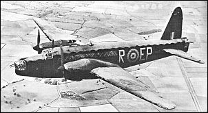 A Wellington Bomber of the type that crashed. |
|
|
As I descended I passed a few more stone boundary markers before leaving the fence and heading north towards the valley descent. I came across a nice outcrop of large boulders then followed along the edge of an escarpment called Crag Brea. There were great views both along the crag and across the valley back to Naughtberry Hill. A very rough track then descended steeply to the road at Temple Lane. It was now much warmer in the valley bottom and I walked along the road back to the car. The lane was narrow and hardly anywhere to park a car so it looks like I’d parked in the right place. |


