|
Garsdale, East Baugh Fell,
Knoutberry Haw, Cumbria. |
|
|
I left my car at the main car park at the western end of Garsdale. I set off east heading up Garsdale, crossing Clough Rover at Danny Bridge. I was on the old road so traffic wasn’t a problem, though I did have to stand in the long roadside grass to let a couple of cars past. There are probably a couple of miles of the old road before the main road is rejoined. I didn’t count them but there are something like 4 or 5 gates to go through. They’re not a problem on foot but I wouldn’t like to drive or cycle along this stretch of road. At Hind Keld East there was a water trough by the road with what looked like a drinking ladle attached to a chain. I’m not sure if it’s intended for the thirsty traveller but it didn’t look the most appetising of vessels to drink out of. |
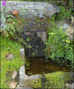 Trough by Hind Keld East. |
|
|
I reached the main road and had to be on constant alert for traffic whizzing by as there is no footpath. I pressed on for a bit over two miles before reaching Kirk Bridge at Garsdale. Thankfully this is where I left the road and headed towards Roger Pot. The path kept to a low level and wasn’t marked. There was a gate in the wall to mark the first part but I soon found myself in woodland with a barbed wire fence blocking the way. I had to climb higher to rejoin the path. It soon emerged onto the frontage of a house called West Paradise Nursery. There was nobody about but it was a magnificent house in a wonderful setting. |
|
I followed the drive down to a bridge then followed another track up to more delightful buildings at West Coat Weggs. The footpath was not marked anywhere and I had to ask the old lady from one of the houses where it was. Back on track I followed an old track and emerged back on the main A684 road at East Little Town. I had just under a mile of this before leaving it at Cock Brow to rejoin the old road. A branch off this road leads to Grisedale where it terminates. |
 West Coat Weggs. |
|
|
I followed it for a while before turning left to head up towards East Baugh Fell. There is no discernable path but a faint quad bike track was there to follow. I was also following the wall line until I had to divert slightly to cross Ceaseat Mire. It’s a wonderful name that conjures up visions of a quaking bog but actually it was relatively dry to cross. The gradient now steepened and after a while a nice rock outcrop appeared that was ideal for a sit down and a chance to eat my lunch. The weather was high cloud but quite pleasant out of the wind. |
|
The views were excellent as I could see east towards Wensleydale and also was looking down on the Dandrymire railway viaduct near the Moorcock Inn. Something else caught my eye and puzzled me. Looking across to the property called Blake Mire it seemed to be habitable with a full roof and all the windows in place. But there was no evidence of a vehicular access. I continued up the fell until the gradient eased then crossed over the wall line where it had been replaced by a fence. |
 View south from East Baugh Fell. |
|
|
A faint path now appeared and I was able to follow it over Tarn Rigg Hill and on to the trig point at Knoutberry Haw. I now had some nice views towards Sedbergh, in fact all around. I didn’t have time to make a detour to the Baugh Fell Quarry but it’s a very interesting place to have a look at if you have time. Descending towards Ringing Keld Gutter there is a faint zig-zag cart track which was most probably the main access to the old quarry workings. The descent is impressive as there are superb views ahead all the way down. A farm track is reached at Garsdale Foot where the road soon takes over and then a short walk back to the car park. |


