|
Longdale, Rispa Pike, Docker
Knott, Simon's Seat, Langdale, Cumbria. |
|
|
After a pleasant and relatively short drove along the M6 I turned off at Tebay and on to the small group of cottages and farms at Longdale. It’s a while since I started one of my walks here and I’m glad I did because further south is the delightful valley of Langdale, the one without the crowds and campsites. I parked on the mown grass by the old school and set off south by the cottages. I hadn’t gone far before I started to chat to Jill who lives at one of the cottages. We’d spoken briefly before on one of my earlier walks here a couple of years ago (12 Oct 2005). We share an interest in photography and also local history. She said that if I wanted to know more about the valley’s history I should talk to Johnny who lives at the farm on the right of the track. |
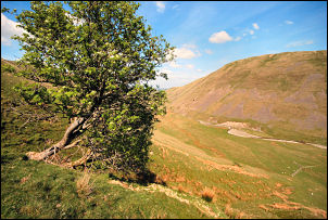
 Heading up Langdale. |
|
|
I followed the rough lane but there was no sign of him. The lane turned to the right then left and over an old stone bridge across Langdale Beck. A disused grassy track then goes diagonally up the valley side until a wall and field at the top. Across the field are the farm buildings of Long Gills. It’s hard to tell if they’ve always been barns or a farmhouse at one time. A stoned track continues up the fell and further up on the left is a branch to Low Shaw. I didn’t go down it as it looked private but the buildings may have been, or maybe, occupied. The track reaches a high point then starts to descend towards Uldale Beck. At this point I left it and headed up the fell onto Uldale End. As I got higher a faint path emerged and I followed it to the summit of Rispa Pike. |
|
There was a substantial stone shelter on the summit and a quite a lot of large stones scattered around. They look as though they could have been part of a structure of some sort. I continued south until I came to the summit of Uldale Head which was marked with a very small cairn. Turning to the left I started the steep descent to the valley bottom and the Blakethwaite Stone which is an old boundary marker. Crossing Blakethwaite Bottom I set off steeply up the other side to Docker Knott. As I continued south I found a nice sheltered spot with a flat shelf where I stopped for my lunch. |
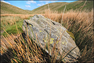 The Blakethwaite Stone |
|
|
A faint path continued towards Wind Scarth and on the final climb I turned left across Wethercalf Moss and up the steep climb of Simon’s Seat. Over the summit was a much easier path heading north and then steeply down into Langdale. I hadn’t been in this part of the valley before and found it a delight to walk along. The bottom is flat and wide and with the river being fairly low the walking was dry. At Middledale End I came to the interesting packhorse bridge and then the path by Langdale Beck. It is fairly wet in parts until I came to the final fields near Town Head and then back to the car. |