|
Newbiggin-on-Lune, Green Bell, Kensgriff,
Yarlside, The Calf, Sedbergh, Cumbria. |
|
|
Drove to Sedbergh and caught the 9am 564 bus to Newbiggin-on-Lune. The £1.90 one way fare took me via the A683 and Ravenstonedale. The sun was warm through the bus windows but as soon as I got off at the only bus stop in Newbiggin the temperature dropped. I sorted my gear at the bus stop then set off to look for the path to Beckstones. It was through a sprung gate and into a field. Approaching the farm the path entered a nice fenced off area adjacent to a river called Dry Beck, a very interesting name. I was soon on a made track and followed it past the farm and out towards Taylor Mire, not a name to look forward to crossing. |
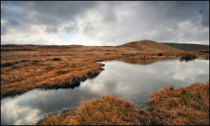 Small tarn with Kensgriff in the background. |
|
|
I left the road and headed south out over the fell. There was a bit of a path to follow and fortunately it was mostly dry underfoot. After leaving the Wythe Mire area I began to gain height heading towards Green Bell which I could see the side of ahead, but not the summit. It was a dry ascent and I came to a more substantial track which looked more like an old drove road. The main track doesn’t go over the summit of the mountain so I left it to reach the summit trig point. I’d been here before but it was over 2 years ago. Down the other side I re-joined the track and followed it to Spengill Head. The main path heads over Randygill Top but I turned off to the left to follow a faint path which traverses the mountain in the direction of Kensgriff. |
|
It’s indistinct at the start but soon becomes better further along the contour. There followed another saddle at the head of Great Randy Gill with a small tarn. I followed the faint path up Kensgriff and began to get a better view of the impressive south east face of Yarlside. At a distance it looks almost impenetrable. A small cairn marks the Kensgriff summit and then a very steep descent to a saddle follows. I managed to find a bit of shelter from the cold wind on the way down and used the opportunity to have my packed lunch while looking up at the vast steep wall I would have to climb. There was a visible path at the start of the climb but it seemed to peter out. When I got there the climb didn’t look so imposing so I set off along the faint path I’d seen from a distance. |
 Cone on the corner of the sheepfold |
|
|
Although steep the going was quite good and there always seemed to be somewhere to get a secure footing. On the summit I didn’t hang around because of the cold wind but it still amazes me that the path over the top is hardly used as this is one of the finest mountains in the area. I continued south to Bowderdale Head then started the steep descent to the main path. There was a nice view of Cautley Spout as I descended. Climbing up the other side I joined the main path up by the waterfalls then continued up Red Gill Beck. I followed the path up the right hand side but as soon as I saw the sheepfold on the opposite bank up ahead I crossed over. The fold was re-constructed by the artist Andy Goldsworthy some years ago. It is one of many throughout Cumbria, each having a distinctive feature. |
|
This one has a very nice cone shape in the NE corner. I crossed the river and headed NW up the fell side to the source of Swere Gill. There are no footpaths here and it is seldom visited. I continued up to reach the main path over the Howgills. Turning left I soon saw the trig point on the summit of The Calf. The wind wasn’t too bad but it was still quite cold. I took some pictures from the summit then headed south along the main path. This is a very enjoyable path when there are views around. It continued over Calders and I began to meet other walker heading out. A steep descent to Rowantree Grain was followed by a rise to the side of Arant Haw then a nice green way descending to Lockbank Farm and back to Sedbergh. |
 View of Sedbergh from the descent. |

