|
Wrynose Bottom, Moasdale,
Stonesty Gill, Little Stand, Great Knott, Red Tarn, Cumbria. |
|
|
As I drove to the summit of Wrynose Pass the weather deteriorated a little. I could still see at the summit but the mountain tops were in cloud. I set off to descend the pass to the west into a gloomy Wrynose Bottom. For the first part of my walk I was on the road so I was able to cover the couple of miles to Cockley Beck fairly quickly. I crossed over by the main road bridge and then over Moasdale Beck using the pedestrian bridge which is constructed from long flat stone flags. I’d been over the bridge before doing a similar walk but this time I wanted to head up Moasdale for a while before climbing Little Stand. Previously I’d followed the line of a footpath show on the map but there isn’t one so the climb was a bit tricky. I followed some very wet ground to the left of Clemety Syke until I came to a gate hole in the wall. |
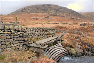 Stone bridge over Moasdale Beck |
|
|
On the 1:25k map the line of the wall is totally obliterated by the Ordnance Survey’s practice of showing thick purple boundaries that are supposed to denote something. I then headed up Moasdale following a narrow path which roughly followed the contour. The weather was still a bit grim but the path was pleasant to walk along. Eventually I came to Stonesty Gill where I set off steeply up the climb to Little Stand. There was now no footpath and I made my way up by the river taking in the nice waterfalls on the way. Snow patches made the going a bit tricky and it wasn’t long before I reached the cloud base and the last of the nice views. Approaching the summit the snow patches go worse as they were deep in places but not strong enough to take my weight. This meant constantly dropping through and having to climb out again. The wind had increased and on the main summit I found shelter behind a large rock outcrop. I didn’t know it at the time but I was only a short way from the main summit cairn. |
|
I used the shelter to sit down for a while and eat my sandwiches. Unfortunately all I could see was cloud and snow. I then headed north using my compass to stop me getting too near the steep drop down into Gaitscale Gill. I emerged from the bouldery terrain onto more level ground and came to the main path from Crinkle Crags. I now knew where I was and started my slippery descent through the snow. I saw the first people of the day as they walked up. Just past Great Knott I came out of the cloud and was able to see below. It was still a tricky descent, mostly due to the snow on the rocky path. As I reached Red Tarn it started to rain a little but I hoped I’d get back to the car before getting too wet. Unfortunately the rain increased steadily and with the wind my trousers were soon soaked. It was my fault for not putting my waterproofs on much earlier. Just after I got back to the car the wind increased and the rain took on torrential proportions. I was glad I got back when I did but I was sorry for the poor souls still on the mountain. |
 A cloudy Little Stand summit. |
