|
Stonethwaite, Langstrath, Cumbria. [ 11 km] Wed 23rd Jan 2008 |
|
|
As I was driving along the shore of Derwentwater it was just coming light and the water level was very high. When I got to Stonethwaite it was raining lightly with a very low cloud level and strong winds. I’d planned to climb Glaramara but decided against it as I’d see nothing and probably get soaked as well. So discretion being the better part of valour I decided on a low level walk instead. It had been ages since I’d had a look up Langstrath so decided that would be my alternative |
 Telephone box at Stonethwaite |
|
|
I still decided to hang around for a while to see if the rain would stop. It did ease slightly so I set off along the road to Stonethwaite. The red telephone box stood out sharply against the very dull surroundings. I decided to take the far side of Stonethwaite Beck so crossed the footbridge and joined the path, which is also the Cumbria Way. Eagle Crag loomed ahead but the summit was lost in cloud. Further up the river is a point shown as Smithymire Island but I didn’t see much of an Island. |
|
As I crossed the footbridge to continue up Langstrath I noticed a sign fitted below the handrail. It said the bridge was re-erected in memory of Gordon Hallworth of Manchester University Mountaineering Club who died nearby in January 1939. Over the river I was walking directly into a very strong wind. I took my time wandering up the path as my walk would be much shorter that planned. I’d made the right decision about staying low as the cloud base was still very low. I battled into the wind as far as the footbridge at Tray Dub and decided to stop for lunch. I found some shelter and enjoyed my sandwiches and the view while watching the rain whiz by overhead. |
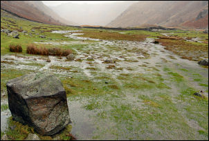 A wet Langstrath |
|
|
I now decided to return via the other side of the river and found it a lot easier as the wind was now behind me. The squally weather continued as I wandered back down the valley. As I approached Blea Rock and the Blackmoss Pot area I saw a group of canoeists who looked like they were about to set off downstream. |
|
I hung around for a while to see if they did. I got closer and watched them prepare as they walked along the bank to check out the waterfalls before returning to their canoes to shoot the rapids. This went on all the way down, and was quite an impressive sight. At Smithymire Island I followed the path close to the riverbank and then through the campsite area. Nobody was camping so I don’t know if it was open or not. The weather was still heavily overcast and dull when I returned to the car, but the rain had stopped. |
|


