|
Barbon, Castle Knott, Middleton Fell, Brackensgill, Sedbergh, Cumbria. [16.5km] Thu 22nd Nov 2007 |
|
|
On Thursdays only there is a bus service between Sedbergh and Kirkby Lonsdale. The route passes through Barbon so I thought it would be a good way to investigate the Middleton Fells with a one way walk over the tops. I was in Sedbergh to catch the 9:45am 567a bus. There were a few people at the bus stop outside the library for 9:45 and when a bus arrived I got on it. It turned out to be the Kendal bus so I got off and continued my wait. Another bus arrived at 9:50 with ‘Kendal Bus Station’ displayed on the front. A closer inspection revealed ‘Kirkby L/dale’ on a piece of cardboard propped up on the front window. This was my bus so I sat down to enjoy the ride. Being a local bus for local people it was interesting to overhear the chat between the driver and passengers as they were all on first name terms. |
 The bus arrives in Barbon. |
|
|
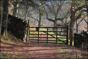
Just as I got off at Barbon Cross light rain started. I set off up the lane passing St Bartholomew’s church on the way. Just after the Church is a left turn which took me over the river and up Pencil Brow. The main path to the fell is shown starting from just over the bridge but I wanted to take the lower path first heading by the River Barbon and heading towards Barbondale. It ducked into the pine woods and followed a delightful path to emerge into open ground at Whiskey Gill. This is where I wanted to climb the fell so I set off straight up and found myself into some difficult and wet bracken. |
|
After a struggle I got to the wall at the north side of Barbon Park and on the other side joined the main path up onto the fell. The cloud was just high enough to clear the fell tops and I had a nice view of the distant Lakeland profile and Black Combe was quite prominent. The wind was chilly (4degC) and still had spots of rain in it so not the ideal walking conditions. At Castle Knott there was an old sheepfold with enough stones standing to get a bit of shelter and have some coffee from my flask. |
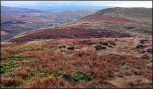 From Calf Top looking south. |
|
|
Over the summit is a descent to a saddle then another climb to the Ordnance Survey trig point (OSBM S5670) on Calf Top. The views are truly astounding and must be even better in good weather. It’s what can be seen that’s amazing. The Lakeland profile, Howgill Fells, Fylde coast, Blackpool Tower and sweeping views into Barbondale. The east side of Calf Top is a steep drop off to Barbondale and Barkin Beck so I descended it a short way to get some shelter from the cold westerly wind and have my lunch. The path is good along the ridge over Barkin Top and when I reached the stone shelter at Long Bank End I left it to make a direct descent to the River Dee. |
|
It is strange that there is only one path over the mountain range and none descend this way. I managed to get down without having to climb any walls or fences but most of the gates had be tied shut, which meant climbing them. I reached Brackensgill Lane near Gale Garth and followed the track down to the river and the footbridge over the River Dee. Up the rough and aptly named Watery Lane I reached the main Dent road which I crossed to Gap Lane. The lane is a walled and very narrow access to a couple of farms and I wouldn’t want to meet a tractor coming the other way. I am now on the main Dales Way and the path crossed over the western tip of Frostrow Fell and descends into Millthrop. It was now just a short stroll along the road to Sedbergh and the end of the walk. |
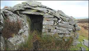 The stone shelter. |