|
Garsdale, Rise Hill, Aye Gill Pike, Yorkshire. 17.8km Thu 11th Oct 2007 |
|
|
It was heavily overcast and rain threatened. I arrived at the large car park at the west end of Garsdale and looked to the mountains to see nothing but mist. I headed east on the old road, firstly downhill to Danny Bridge over the Clough River. The narrow road heads up then winds between various stone houses. It is virtually deserted now but once must have taken all the Garsdale traffic before the new(ish) road went through. The centre of the road is now grassed over which gives an idea of its usage. |
 Danny Bridge, Garsdale. |
|
|
Passing Hind Keld East I noticed an English Heritage Listed Building plaque mounted on the barn wall. I passed 2 or 3 gates along its route before descending back to the main road below. Walking was a lot more hazardous as there was no footpath. |
|
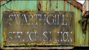
At Swarthgill House I came to a remnant of past occupation. A faded sign on the building opposite said Swarthgill Service Station and on the overgrown forecourt were two very old petrol pumps. I arrived in Garsdale to even more dilapidated buildings. These were right by the road but had trees growing out from the inside. A little further on was Street Chapel, a Primitive Methodist Chapel dating from 1841. Just after Dandra Garth I noticed a small wooden gate, almost hidden, with the notice ‘Quaker Burial Ground’ on it. A small enclosed area of grass was beyond and what looked like a wooden seat in a corner, but no sign of graves. Unfortunately I shouldn’t have been this far along the valley as I’d overshot my turn off. It was a couple of hundred meters before I realised my mistake and had to turn back. At Dandra Garth I found the path and followed it up into the forest. |
|
|
|
It was rough, wet and soon I was in mist. I reached a gate and headed out onto wet moor land. The map shows a track but nothing was to be seen. I headed in what I thought was the right direction and came to a small stream where I joined the path. It was wet, boggy and indistinct. A couple of marker posts were all I had to keep me on the right track. Near the summit it flattened off and became extremely boggy. A few wooden walkways had been placed across the worst bits but water and mud had to be negotiated to get on them. I now had hardly any visibility as I was in thick cloud, but at least it wasn’t raining. The summit of the pass is called Black Hill and from now my navigation would be easy as I came to the wall that traverses the full length of Rise Hill and Aye Gill Pike. Unfortunately for the first bit there was no path to follow. Eventually I came to the ever familiar quad bike tracks which made the going a lot easier. The going got better the further west I walked. |
|
I was now heading into a bit of a headwind but managed to find some shelter behind a wall where I stopped for my lunch. With nothing to see I ploughed on until the trig point on Aye Gill Pike appeared. There was a stile over the fence which helped access. Someone must have adopted it as it was painted white all over including the brass plate on the side with the bench mark and identifying letters OS BM S5665. The wall continued along the spine of the hill until I reached a Y branch. The map showed the right wall descending directly to the road. I followed it down and eventually came out of the cloud and could see the car park below. It was now early afternoon and I could only see two cars through the gloom. Though I didn’t see much at least the rain held off. As I drove home the rain started. |
|